

The Gustine Historical Society~Gustine Museum

Photo by adam blauert
The Gustine Historical Society
Wishes to discover, preserve and disseminate knowledge about the history of Gustine and the West Side.
It collects artifacts, memorabilia, documents, books, maps, periodicals, articles, photographs and items pertaining to Gustine and its surrounding area.
These artifacts are housed in the Wilbur and Irene Gomes Gustine History Center and in creative exhibits in the Gustine Museum.
Location
Gustine Museum 397 Fourth Street Highway 33 Gustine, CA 95322
Phone (209) 854-2344
www.gustinehistoricalsociety.org
Jail House
The Gustine Museum is housed in the former Merced County Justice Court/Jail building.
Built in 1911, this historic building served the City of Gustine until abandoned in 1980, when the Police Department moved to new quarters. It was leased to the Gustine Historical Society in 1985.
After extensive restoration, it reopened in 1990 as the Gustine Museum. In 1996 the building was designated a California Point of Historic Interest.
Open Thursdays and Sundays
1:00 p.m. to 4:00 p.m.
- Admisssion Free -

History-Center-- photo by adam blauert
Wilbur and Irene Gomes Gustine History Center
323 Sixth Street Gustine, CA
Phone (209) 854-6455
The History Center…
dedicated on July 4, 1997, owes its existence to the generous contribution of long-time activists Wilbur and Irene Gomes.
This remarkable center showcases a wide array of resources, including an archival library, Gustine newspapers dating back to 1911, obituaries, biographies, histories, maps, Gustine school registers, Indian lore, and an extensive collection of photographs.
For visitors' convenience, the center is open on Thursdays and Sundays from 1:00 p.m. to 4:00 p.m.
Additionally, appointments can be arranged by contacting (209) 854-3120.
To correspond with the center, please use the following mailing address:
PO Box 222, Gustine 95322.
For any inquiries, please dial the new phone number: 209-854-6455.

YOSEMITE LAKE IN MERCED
OPEN Mon-Fri 7:30 AM and Weekends 7:30 AM - Closed at Dusk
(Next to UC Merced)

Yosemite Lake 2023


Just down the street from UC Merced....enjoy the beauty!

YOSEMITE LAKE - PHOTO BY ADAM BLAUERT
Lake Yosemite
Only seven miles from the center of Merced, Lake Yosemite has long been a popular spot for picnics, family outings, group activities, fishing and boating.

Lake-Yosemite- - PHOTO BY ADAM BLAUERT
It isn’t the largest lake in Merced County, but it is close to home and has extensive recreational facilities.
Most facilities are accessed from Lake Road, but a secondary fishing access point is located at the end of Old Lake Road.
Lake Yosemite’s water comes from the Merced River
It is diverted into the Main Canal by the Crocker-Huffman Dam, halfway between Snelling and Merced Falls. Surface area of lake: 500 acres.

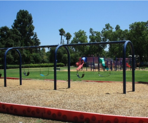
Playground - PHOTO BY ADAM BLAUERT
Rentals Available at Lake Yosemite
Facilities and activities:

Boat ramp and marina
Concessions booth (summer weekends only)
Flush restrooms
Drinking fountains
Picnic areas with tables, shelters, and BBQ grills
Camping area for youth groups
Swimming beach
Playground
Dogs allowed? No
Horses allowed? No
Hunting allowed? No
Fish species: Bass, bluegill, and catfish. Trout are stocked in the early spring, but don’t last through the summer because of water temperatures.

Yosemite Lake - 2021 by Brad Haven
Rentals
Non-motorized boats are available on summer weekends from the concession stand.
Nearby parks:
The closest camping is available at McConnell State Recreation Area, and Lake McClure and Lake McSwain.
Recreation organizations
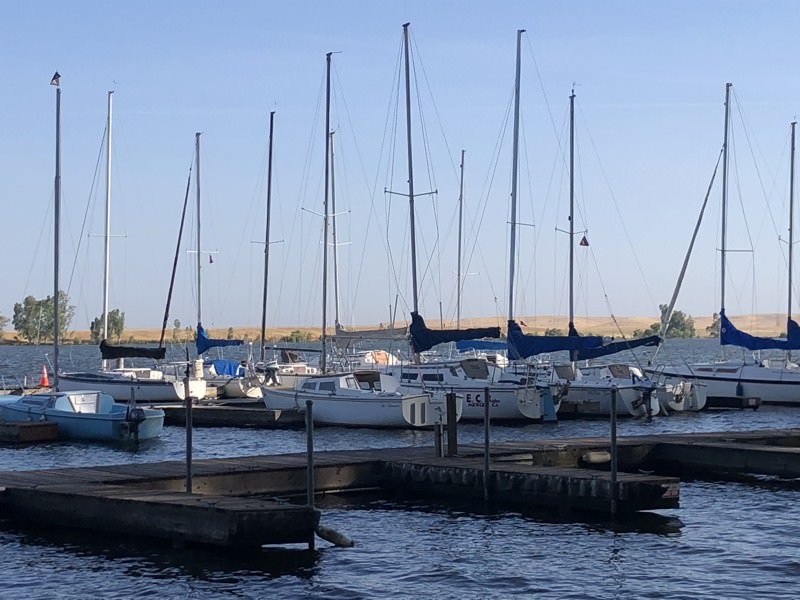
The Lake Yosemite Sailing Association organizes sailboat events and races, maintains a docking area, and teaches sailboating skills.
Membership is open to all who have an interest in sailing.
Boat ownership is not required and new members can learn to sail by crewing on boats owned by other members.
The LYSA also offers a Sail Camp for youth aged 8 and up during the summer months. http://www.lakeyosemitesailing.org/

Lake Yosemite - PHOTO BY ADAM BLAUERT


Lake McSwain and Lake McClure
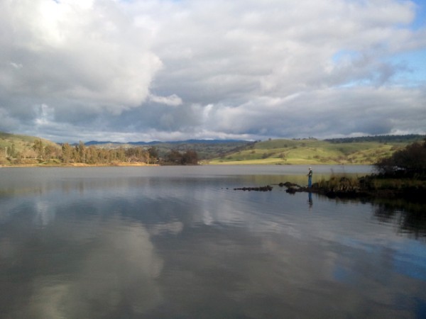
PHOTO BY ADAM BLAUERT

photo by adam blauert
Lake McSwain and Lake McClureLake McSwain and Lake McClure: These two sister reservoirs on the Merced River are operated as a unit by the Merced Irrigation District. Both provide excellent fishing.
Lake McSwain may be tiny in comparison to Lake McClure, but sometimes has better trout fishing. Gigantic Lake McClure is especially popular for waterskiing, wake boarding, and houseboats.
A 15-mile trail between the Bagby Recreation Area (Highway 49) and Briceburg (140) provides good river fishing, hiking, and mountain biking.

bike park
Location: Lake McClure Road near Merced Falls
Distance from Merced: 30 miles
Distance from Los Banos: 66 miles
Operating authority: Merced Irrigation District
Surface area of lake: McClure 7,110 acres, McSwain 308 acres
Facilities and activities
Boat ramps, marina, fish-cleaning stations
Flush restrooms
Drinking fountains
Campgrounds/group campgrounds with BBQ grills/fire rings, shelters, hot showers, RV hookups
Picnic areas with tables, shelters, and BBQ grills
Group picnic areas and shelters
Swimming beach
Playgrounds
Store, laundry facilities, dump station
Dogs allowed? Yes
Horses allowed? No
Hunting allowed? No
Fish species: bass, bluegill, catfish, crappie, shad, sunfish, trout
Rentals: Boats and personal watercraft including houseboats
Website: http://www.lakemcclure.com/
Merced County Parks
Lake Yosemite - PHOTO BY ADAM BLAUERT
Merced County offers three large regional parks –
and Lake Yosemite.
Hagaman and Henderson are both situated on the Merced River.
Lake Yosemite wraps around the southern side of a reservoir just outside the City of Merced.
Henderson is my personal favorite with the nicest facilities and plenty of shade provided by tall trees.
Note: pets are not allowed in Merced County Parks, but are welcome in California State Parks and at reservoirs operated by local irrigation districts and the Army Corps of Engineers.
County Park Resources:
County Park Facility Rental Fees: http://www.co.merced.ca.us/index.aspx?NID=761
Frequently Asked Questions About County Parks: http://www.co.merced.ca.us/FAQ.ASPx?QID=279
County Park Rules: http://www.co.merced.ca.us/index.aspx?NID=789

photo by adam blauert
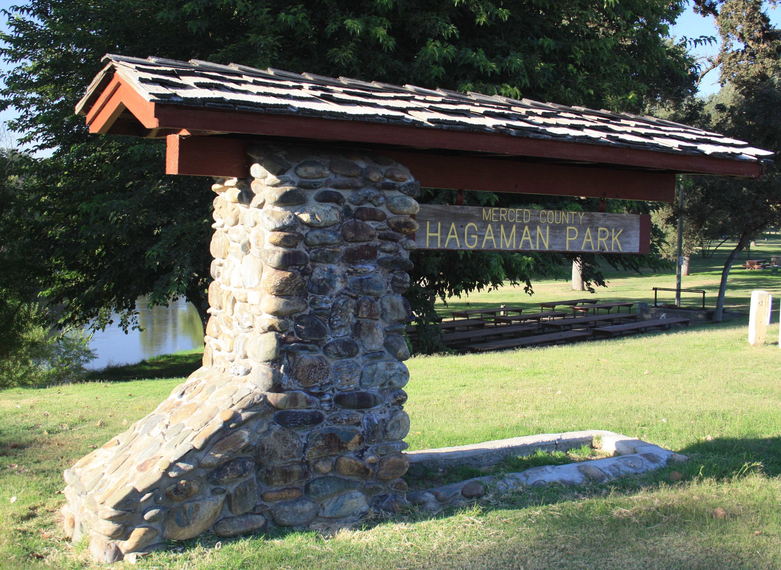
Hagaman Park:
Located on a bluff above the Merced River in northwestern Merced County, Hagaman Park is especially popular with residents of the west side of the county. A large picnic area is available for rent. Because of drownings, this area is not open to fishing and a fence runs along the bluff to discourage river access. If you want to swim or fish in the Merced River, try Henderson County Park, George J. Hatfield State Recreation Area, or McConnell State Recreation Area.
Location: 19914 River Road, Stevinson, CA (Intersection of River Road and Highway 165)
Distance from Merced: 24 miles
Distance from Los Banos: 23 miles
Facilities and activities:
Flush restrooms
Drinking fountains
Picnic areas with tables, shelters, and BBQ grills
Group picnic areas and shelters
Playground
Fishing or boating? No
Website: http://www.co.merced.ca.us/index.aspx?NID=1410
Nearby Parks: Camping and picnic areas are available at George J. Hatfield State Recreation Area, McConnell State Recreation Area, and San Luis State Recreation Area.
Henderson Park:
Stretched along the bank of the Merced River in eastern Merced County, Henderson Park is shaded by tall trees and further back from the road than the facilities at Hagaman County Park or George J. Hatfield State Recreation Area.
Like McConnell State Recreation Area, it feels more distant and removed than it actually is. The park is popular for picnicking, large gatherings, river recreation, and fishing. Three rental facilities are available, including an indoor clubhouse with kitchen and fireplace.
Location: Merced Falls Road, 1 mile east of Snelling
Distance from Merced: 20 miles
Distance from Los Banos: 55 miles
Facilities and activities:
Flush restrooms
Drinking fountains
Picnic areas with tables, shelters, and BBQ grills
Group picnic/banquet facilities (indoor and outdoor)
Swimming area
Playground
Softball diamond
Horseshoe pits
Dogs allowed? No
Horses allowed? No
Hunting allowed? No
Fishing and boating: Fishing for rainbow trout is popular along the river and small boats can be hand launched from a concrete ramp (vehicles are not permitted near the ramp).
Nearby Parks: Camping is available at McConnell State Recreation Area, and Lake McClure and Lake McSwain.
Lake yosemite - photo by adam Blauert
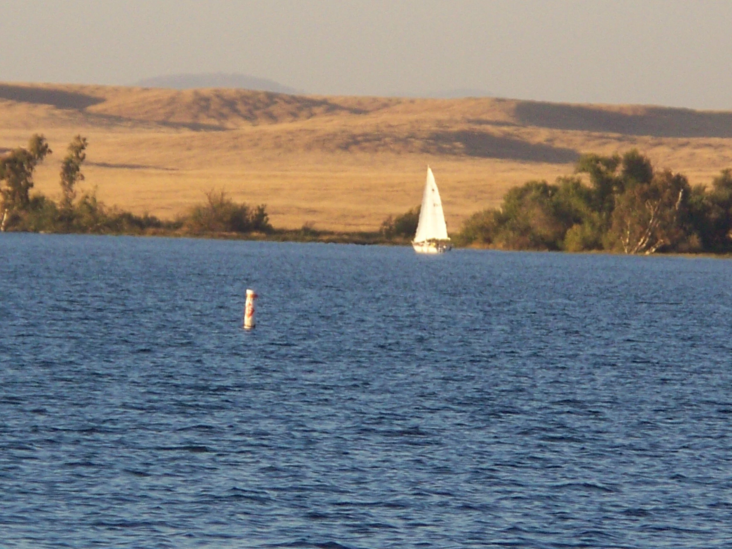
Lake Yosemite:
Only seven miles from the center of Merced, Lake Yosemite has long been a popular spot for picnics, family outings, group activities, fishing and boating. It isn’t the largest lake in Merced County, but it is close to home and has extensive recreational facilities. Most facilities are accessed from Lake Road, but a secondary fishing access point is located at the end of Old Lake Road. Lake Yosemite’s water comes from the Merced River. It is diverted into the Main Canal by the Crocker-Huffman Dam, halfway between Snelling and Merced Falls.
Location: 5714 Lake Road, Merced, CA 95340
Distance from Merced: 7 miles
Distance from Los Banos: 43 miles
Operating authority: Merced County Parks and Recreation
Surface area of lake: 500 acres
Facilities and activities:
Boat ramp and marina
Concessions booth (summer weekends only)
Flush restrooms
Drinking fountains
Picnic areas with tables, shelters, and BBQ grills
Group picnic/banquet facilities (indoor and outdoor)
Camping area for youth groups
Swimming beach
Playground
Dogs allowed? No
Horses allowed? No
Fish species: Bass, bluegill, and catfish. Trout are stocked in the early spring, but don’t last through the summer because of water temperatures.
Rentals: Non-motorized boats are available on summer weekends from the concession stand.
Website: https://www.co.merced.ca.us/769/Lake-Yosemite
Nearby parks: The closest camping is available at McConnell State Recreation Area, and Lake McClure and Lake McSwain.
Recreation organizations: The Lake Yosemite Sailing Association organizes sailboat events and races, maintains a docking area, and teaches sailboating skills.
Membership is open to all who have an interest in sailing.
Boat ownership is not required and new members can learn to sail by crewing on boats owned by other members. The LYSA also offers a Sail Camp for youth aged 8 and up during the summer months. http://www.lakeyosemitesailing.org/

Visit the Parks of Merced City

Photo by adam blauert
Merced City Parks
The City of Merced maintains a wide range of neighborhood, regional, and community parks within the city limits. Many of these parks are located along Merced City Bikeways.
Information on bike routes is included in the descriptions below.
Applegate -photo by adam blauert
The city’s largest parks include
Fahrens Park
Joe Herb Park
McNamara Park
Merced Dog Park
Rahilly Park
Youth Sports Complex
Neighborhood Parks
...are located within a half mile walk of nearly every home in Merced. To find a park in your neighborhood, click on this link to view a map on the City of Merced’s website:http://www.cityofmerced.org/civica/filebank/blobdload.asp?BlobID=7595
This map also shows parks that the City plans to build in coming years.

Kiddieland - PHOTO BY ADAM BLAUERT
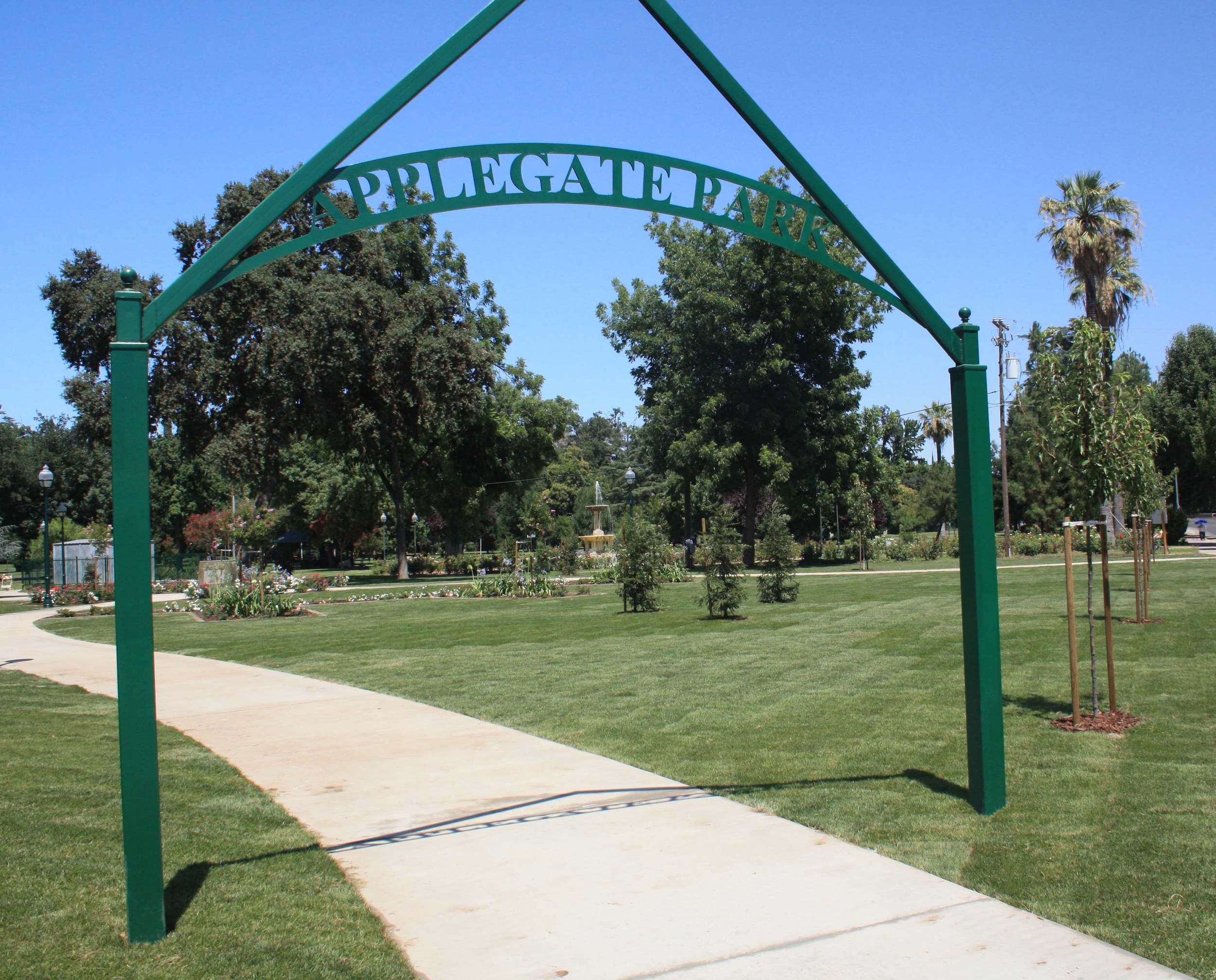
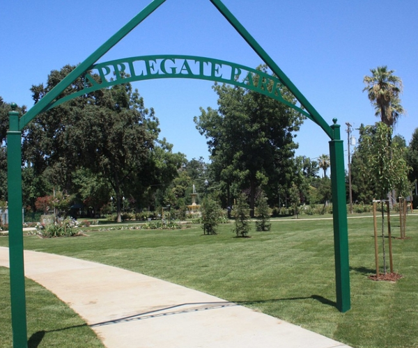
Applegate Park
Applegate Park is Merced’s central park. Located along the Bear Creek Bikeway, the park is an excellent destination on bike or foot.
It offers 32 acres of recreation with a zoo, outdoor theater, picnic tables, bbq grills, volleyball nets, tennis/basketball courts, a skate park, rental facilities, a large playground, a rose garden, fountain, and the Kiwanas-sponsored Kiddieland amusement park.
Plenty of parking is located around the park.
Many community events are held at Applegate, including concerts and plays in the summer.

Fahrens Park - PHOTO BY ADAM BLAUERT
Fahrens Park
Stretched out along both Faherns and Black Rascal Creeks, this park boasts a brand new disc golf course and plenty of shade.
Fahrens Park - PHOTO BY ADAM BLAUERT
Fahrens Park features a frisbee course
Location: Along Buena Vista Drive between R Street and Highway 59.
Size: 48 acres
Facilities:

bike rider
Restrooms and drinking fountains
Picnic tables, BBQ grills
Playground
Disc golf course (course map: http://www.cityofmerced.org/documents/discgolfMap8x11.pdf)
Bikeway connections: Located along the Rascal Creek Bikeway. For a map, go to:http://www.cityofmerced.org/documents/MercedCityBikePlan.pdf
For information about the bike trails of Merced, click here.
Joe Herb Park
Adjacent to Golden Valley High School, this park provides a large area for recreation in southeast Merced. City league softball games are often held on the lighted softball fields.
Location: 2200 Yosemite Parkway, Merced
Size: 27 acres
Facilities:
Restrooms and drinking fountains
Picnic tables and shelters, BBQ grills
Playground
Concessions stand
Baseball/softball diamond
Horseshoe pits
Soccer fields
McNamara Park
Centrally located in south Merced, McNamara Park offers a broad range of recreational activities and plenty of shade.
Location: 1040 Canal Street, Merced, Ca
Size: 9 acres
Facilities:
Restrooms and drinking fountains
Picnic tables and shelters, BBQ grills
Playground
Concessions stand
Recreation hall
Baseball/softball diamond
Basketball courts
Horseshoe pits
Soccer fields
Swimming pool
Dog Park - PHOTO BY ADAM BLAUERT
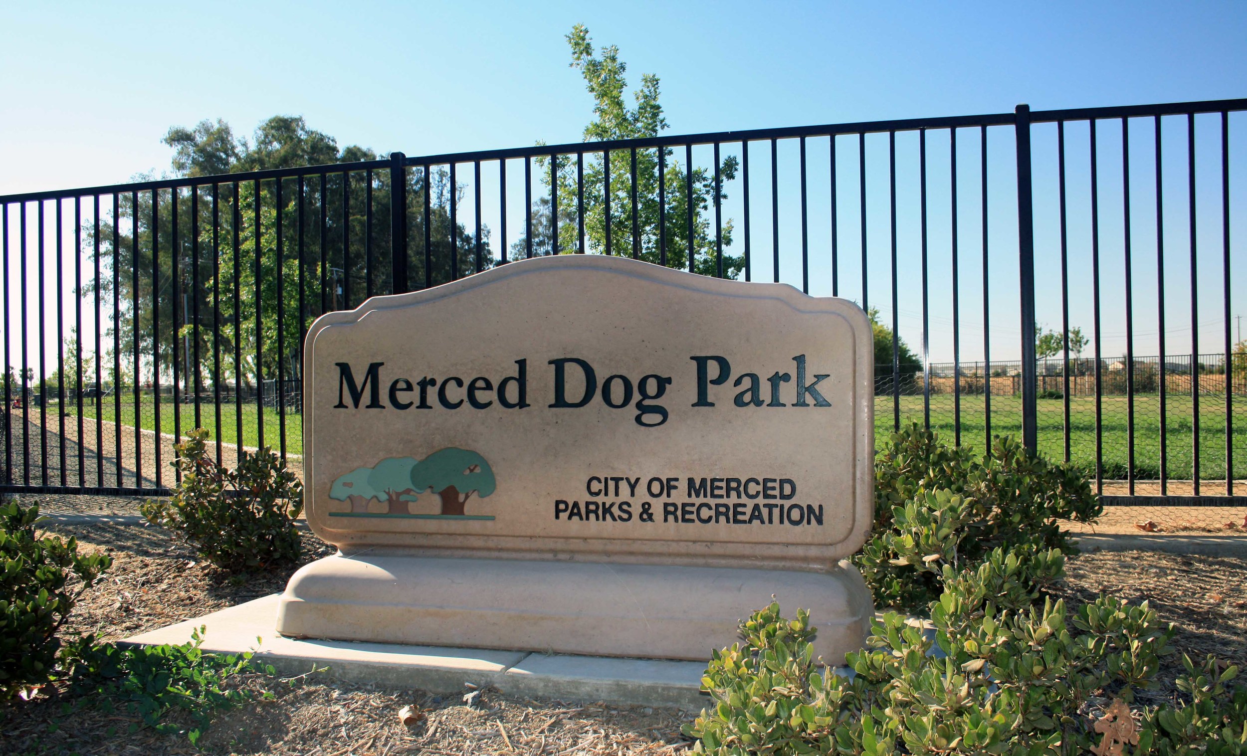
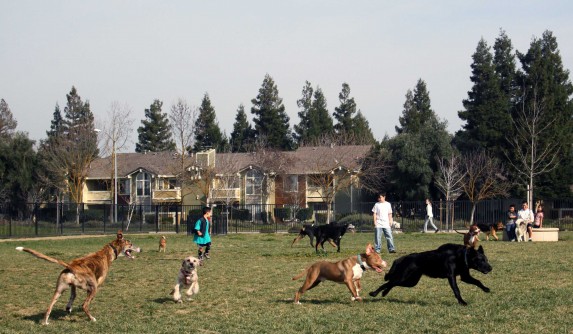
Merced Dog Park
Looking for a place to allow your dog to play off-leash with other dogs? The Merced Dog Park has well-fenced areas for both small dogs and larger dogs.
For information about the local dog club:
M-DOGS (Merced Dog Owners Group)
Location: Yosemite and R Streets
Merced Dog Park - PHOTO BY ADAM BLAUERT
Size: 8 acres
Facilities:
Restrooms and drinking fountains
Pet waste bag dispensers
Picnic tables
Bocce ball courts
Bikeway connections: Located along the Fahrens Creek Bikeway. For a map, go to:http://www.cityofmerced.org/documents/MercedCityBikePlan.pdf

Dog Park - PHOTO BY ADAM BLAUERT

Rahilly Park 3
Rahilly Park
A shady creekside park in the center of north Merced, Rahilly Park has long been a favorite with families.
To avoid confusion, note that Google maps and other online map sources may refer to this park as “Black Rascal Park.”

Rahilly Park - PHOTO BY ADAM BLAUERT
Rahilly Park
Location: 3302 Parsons Avenue, Merced
Size: 17 acres
Facilities:
Restrooms and drinking fountains
Picnic tables and shelters, BBQ grills
Playground
Soccer fields
Bikeway connections: Located along the Rascal Creek Bikeway. For a map, go to:http://www.cityofmerced.org/documents/MercedCityBikePlan.pdf
Youth Sports Complex
Location: 1800 Block of Wardrobe Avenue, Merced
Size: 12 Acres
Facilities:
Restrooms and drinking fountains
Concessions stand
Baseball/softball diamond
Soccer fields
Welcome to the Recreation Safety Recommendations

Adam Blauert
The purpose of this page is to provide a comprehensive database of recreation within Merced County and an hour’s drive of cities within the county.
Your author, Adam Blauert, is an outdoorsman and outdoors columnist for the Merced Sun-Star. You can read his weekly column about outdoor recreation at www.mercedsunstar.com. Please direct comments, feedback, and suggestions to AdamBlauert@yahoo.com. It is our goal to provide useful and relevant information about all types of recreation in our area.
A note on safety: All outdoor activities involve some degree of risk or injury.
The keys to being safe include:
Making sure you are in the proper physical condition before trying a new activity. Check with your doctor if you are uncertain about your condition and abilities.
Taking lessons or training before attempting an activity that requires specialized skills.
Enjoying outdoor recreation with family or friends. Never hike, swim, or boat alone. Make sure that someone outside your group knows where you are going and when you expect to return before you leave home.
Wearing proper safety gear and equipment. When boating or swimming outside of a swimming pool, make sure that life jackets and flotation devices are available for each person in your group.
Checking current conditions such as weather and water conditions. If you have any questions contact the agency that operates the recreation area that you plan to visit.
Drinking plenty of water to avoid dehydration.
Not using alcohol or illegal drugs.
Wearing sunscreen, sunglasses, and hats to avoid sunburn.
Bringing extra layers of clothing and rain gear in case of a change in weather.
Having a first aid kit available and being knowledgeable about common first aid procedures and CPR.
Having a cellular phone available to call for help if an accident occurs. Cellular reception is available within much of Merced County.
It is your responsibility to know and monitor conditions. All information provided on this website describes optimal conditions. Conditions can change rapidly.
For general information
Concerning safety for a variety of outdoor activities, see: http://www.surviveoutdoors.com/
-
Adam
Blauert
69
- Apr 28, 2014 McConnell State Recreation Area
- Apr 29, 2014 Modesto Reservoir Regional Park
- May 26, 2014 Tuolumne Meadows – The Other Yosemite
- May 27, 2014 Rainbow Pool – A Great Swimming Hole on the South Fork of the Tuolumne
- Jun 2, 2014 Pacheco State Park
- Jun 8, 2014 Don Pedro Lake - One of California's highest-rated fishing area & 5th largest artificial lake
- Jun 13, 2014 Reservoirs, Fishing, and Boating within an Hour of Merced County Communities
- Jun 15, 2014 Eastman Lake: Formed by a dam on the Chowchilla reservoir, this tends to be more popular than nearby Hensley Lake.
- Jun 15, 2014 Hensley lake ~ Very close to Merced County with many facilities
- Jun 24, 2014 Kearney Park and Mansion
- Jun 28, 2014 George J. Hatfield Recreation Area Merced County
- Jun 29, 2014 Sierra Foothill Conservancy
- Jul 6, 2014 Fossil Discovery Center of Madera County
- Jul 13, 2014 Dos Palos Museum
- Jul 14, 2014 Meux Home Museum
- Jul 16, 2014 Great Bike Paths in Merced County
- Jul 17, 2014 Merced’s Multicultural Arts Center
- Jul 20, 2014 Merced County Wildlife Refuges
- Jul 21, 2014 Raymond Museum
- Jul 22, 2014 George J. Hatfield Recreation Area
- Jul 25, 2014 Fresno Chaffee Zoo
- Jul 31, 2014 Livingston Historical Museum
- Aug 2, 2014 Henderson Park
- Aug 3, 2014 Sierra National Forest
- Aug 9, 2014 Turlock Lake State Recreation Area
- Aug 13, 2014 Romero Visitor Center – San Luis Reservoir
- Aug 29, 2014 McHenry Mansion and Museum
- Aug 30, 2014 Yosemite – The Other Three Seasons
- Sep 2, 2014 Merced County Historical Society Museum
- Sep 13, 2014 Moccasin Trout Hatchery
- Sep 14, 2014 Clovis Botanical Garden
- Sep 20, 2014 Shinzen Japanese Garden
- Oct 5, 2014 Local Performing Arts
- Oct 17, 2014 Oakdale Cowboy Museum
- Oct 18, 2014 Castle Air Museum-Atwater
- Nov 12, 2014 Mariposa County Museums
- Nov 16, 2014 Gold Rush Towns of the Central Foothills
- Nov 18, 2014 San Juan Bautista
- Nov 19, 2014 Calaveras Big Trees
- Nov 24, 2014 Turlock Museums
- Nov 26, 2014 Visit Hagaman Park-Merced County
- Dec 5, 2014 Milliken Museum and Los Banos Historic Sites
- Dec 26, 2014 Stanislaus National Forest
- Dec 27, 2014 Madera County Museum
- Jan 31, 2015 Merced's Central Park: Applegate Park, Zoo & Kiddieland Merced
- Feb 15, 2015 Fishing and Floating the Merced River
- Mar 17, 2015 Tuolumne County Museum
- Mar 20, 2015 San Luis Reservoir Area
- Apr 6, 2015 Forestiere Underground Gardens
- Oct 28, 2015 MJC’s Great Valley Museum and Planetarium
- Dec 29, 2015 Top 5 things to do in the Fall in and around Merced County
- Jan 6, 2016 Yosemite National Park Winter Activities
- Jan 27, 2016 State Parks and State Recreation Areas in Merced County
- Jan 31, 2016 Chowchilla’s Historical Society & Museum
- Feb 1, 2016 Fresno’s Christmas Tree Lane
- Feb 1, 2016 Downing Planetarium at Fresno State University
- Feb 17, 2016 Top 5 Things to do in the Spring in and Around Merced County
- Feb 19, 2016 Blossom Tours
- Sep 11, 2017 Pumpkin Patches and Fall Farm Events
- Jun 1, 2019 Swimming Pools in Merced County area
- Jun 10, 2019 Top 5 things to do in the summer in and around Merced County
- Jan 2, 2020 Top Five Things to do in and around Merced County
- Jan 9, 2020 Top 5 Local Things to do in Winter in and Around Merced County
- Apr 29, 2020 Welcome to the Recreation Safety Recommendations
- Apr 30, 2020 Visit the Parks of Merced City
- Apr 30, 2020 Merced County Parks
- May 4, 2020 Lake McSwain and Lake McClure
- Jul 8, 2021 YOSEMITE LAKE IN MERCED
- Mar 30, 2023 The Gustine Historical Society~Gustine Museum
-
Merced County
Events
5
- Nov 15, 2012 The Atwater Historical Society was formed in 1972 in response to the challenge of keeping the Bloss Home for the community.
- Jan 7, 2014 The Merced County Library
- Feb 1, 2014 "Only What you can Carry"
- Mar 14, 2016 Kiddieland in the Applegate Park next to the Merced Zoo
- Oct 25, 2018 Bakersfield Music Hall of Fame
-
Brad
Haven
1
- Sep 27, 2015 The Mystery Spot and Point Lobos State Reserve

Swimming Pools in Merced County area

Swimming Pools
Community swimming pools are located throughout Merced County. Programs include swimming lessons, recreational swimming, and pool rentals.
A variety of local swim leagues provides the opportunity for youth to improve their swim skills and compete in swim meets. Scroll down to explore the possibilities.
Atwater - (209) 357-6320
Delhi - (209) 656-2000
Dos Palos - (209) - 392-2178
Gustine - (209) 854-6471
Hilmar - (209) 667-6947
Livingston - (209) 394-8830
Los Banos - (209) 826-3801
Merced - (209) 385-6978
Local Swim Leagues
Swimming is also possible at the following reservoirs, state, and county parks
Atwater
Recreational swimming is offered Monday through Friday from 1 to 4 PM and Saturday from 12 to 4 PM. Swim lessons for children are also available.
Location: 2201 Fruitland Avenue, Atwater, CA 95301
For current information, including swim lesson schedules, call Atwater’s Department of Parks and Community Services at (209) 357-6320.
We are offering 3 sessions: June 12 thru June 23, July 3 thru July 14 and July 17 thru July 28. We offer: 11am, 12am, 1pm,3pm, 4pm, 5pm, and 6pm classes each class is for one hour a day Monday thru Friday. Each session cost $45 per child.
Delhi
Located at Delhi High School, the Delhi pool offers recreational swimming, family swim nights, and swim lessons during the summer months. During the summer of 2016, the pool will be open from June 28th through August 6th.
Swim hours are Tuesday through Saturday from 12 to 4 PM. Admission is $1. A special family swim night is offered every Friday, with the pool open from 5 to 7:45 PM. Admission on family swim nights is $0.75 per person.
Location: Delhi High School, 16881 W. Schendel Road, Delhi.
For more information, contact the Delhi Unified School District at (209) 656-2000.
Dos Palos
The pool at Dos Palos High School offers swimming lessons and recreational swim hours during the summer months.
Recreational swim hours: 12-4PM M-F, $1/person
Adult lap swim: 7-8:30PM, $1/person
Location: Dos Palos High School, corner of Mabel Avenue and Palo Alto Street.
For current information call City of Dos Palos Parks and Recreation at 392-2178.
Gustine
The Gustine Aquatics Center at Henry Miller Park offers the following programs during the summer months: water aerobics, open swim, night swim, and pool rental.
Location: Henry Miller Park, corner of 3rd Ave. and 6th St., Gustine, CA
For more information call Gustine City Hall at (209) 854-6471.
The pool is open from 9 to 10 AM Monday through Thursday for adult lap swim. Open swim is held Monday through Friday from 12 to 4 PM.
NIght swim is offered on Tuesday andThursday nights form 6 to 8 PM. Admission is $3/person or $2 for senior citizens.
You can save money by paying in advance and for those who want to swim frequently, unlimited visit passes are available.
Water aerobics and swim lessons are also offered - see the City of Gustine webpage for more information: http://www.cityofgustine.com/newsView.aspx?nid=2963.
Hilmar
Located in Hilmar Park, the pool offers swimming lessons, recreational swimming hours, water aerobics, and lap swimming.
Location: Hilmar Park, corner of Lander Avenue and Falke Street.
Morning lap swim: 6:30-8 AM, Monday-Friday
Combined lap swim and water aerobics: 12-1 PM, Monday-Friday
Evening lap swim: 6:30-PM, MWF
Recreational swim: 1-4 PM Tuesday - Friday, 12-3 PM Saturday
Water boot camp: 7:30-8:30 PM, Tuesday and Thursday
Swim Lessons 4:30-6:30 PM Monday through Thursday in 2-week sessions
To sign up for swim lessons or for more information call the pool at 667-6947 between 1 and 4 PM on a weekday.
Hilmar Hammerheads Swim Team
Website - http://www.hac.teampages.com/
Livingston
The Livingston High School pool - 209-394-8830
FOR 2017 THE SWIMMING POOL IS CLOSED FOR CONSTRUCTION.
Location: 1617 Main Street, Livingston, CA 95334
For more information call Livingston City Hall at 209-394-8830.
Los Banos
Swimming lessons and open swim hours are offered at the Los Banos County Park during the summer months.
Location: 1414 South 7th Street, Los Banos, CA 93635
For more information call the Los Banos School District at (209) 826-3801
Merced
The City of Merced operates city pools at
Ada Givens Park
McNamara Park
Stephen Leonard Park.
These pools are available to rent for private events. Swim lessons are offered for children of all ages starting with a “parent and me” class for toddlers as young as six months.
Merced College offers a variety of swim programs during the summer and throughout the year.
City of Merced Swim Lessons: Four two-week sessions are offered from June through early August. Five levels of instruction include:
Parent and Me (Ages 6 months to 3 years)
Tiny Tots 1: (Ages 3 to 5 years)
Tiny Tots 2 (Ages 4 to 6 years)
Beginner Prep: (Ages 6 to 10 years)
Stroke Technique: (Ages 7 years and up)
Call the city at 385-6978 for more information and current schedules.
City of Merced Recreational Swim Programs
The City of Merced offers swimming during the summer at McNamara Park, Golden Valley High School, and Merced High School.
Swim lessons are offered for children of all ages starting with a “parent and me” class for toddlers as young as six months. Merced College offers a variety of swim programs during the summer and throughout the year.
City of Merced Swim Lessons: Three two-week sessions are offered from June through July. For the summer of 2016, there are still some lessons available at MacNamara Park in the mornings. Five levels of instruction include:
Parent and Me (Ages 6 months to 3 years)
Tiny Tots 1: (Ages 3 to 5 years)
Tiny Tots 2 (Ages 4 to 6 years)
Beginner Prep: (Ages 6 to 10 years)
Stroke Technique: (Ages 7 years and up)
Call the city at 385-6978 for more information, schedules, and to sign up.
City of Merced Recreational Swim Programs: The Memorial Plunge at McNamara Park and the Golden Valley High School pool are available for recreational swimming on summer afternoons.
Recreational swim hours:
Golden Valley High School: Saturday and Sunday, 3-6PM
MacNamara Park: Thursday-Sunday, 3-6 PM
The cost for admission - please call.
Youth under age 18 swim free on Fridays at MacNamara Park.
City of Merced Pool Rentals:
For more information, call the city at 385-6978.
Rentals are available from May through August.
Location of City of Merced Pools:
Memorial Plunge at McNamara Park: Corner of 11th and K Streets, Merced
Golden Valley High School Pool: 2121 E. Childs Ave., Merced, CA 95341
Merced High School Pool: 205 W. Olive Ave., Merced, CA 95348
Map of city pools-(click here)
Merced College Pool: Merced College’s Community Service Department provides recreation classes for all ages. Programs for children include swimming lessons, diving lessons, and water polo.
Adult recreational lap swimming is offered throughout the year.
Location: North end of Stadium Lane near Parking Lot B1, Merced College campus
For more information call (209) 384-6224.
Merced College Pool: Merced College’s Community Service Department provides recreation classes for all ages. Programs for children include swimming lessons, diving lessons, and water polo. Adult recreational lap swimming is offered throughout the year.
For more information go to: (Click Here)
or call (209) 384-6224.
Local Swim Leagues
The Merced County Swim League is made up of ten teams from Merced County and surrounding communities. Merced is also home to the Merced Skimmers Swim Team, which practices regularly at Merced College.
Skimmers offers youth programs and masters swimming for adults.
Contact Information
Merced Skimmers

Website: http://www.mercedskimmers.com/
Merced County Swim League

Atwater stingrays

Hilmar Hammerheads
www.hac.teampages.com Sign-ups start in February
Contact: Celeste Tremble arnica19@hotmail.com

Los Banos Tigersharks
Website: http://www.lbtigersharks.org
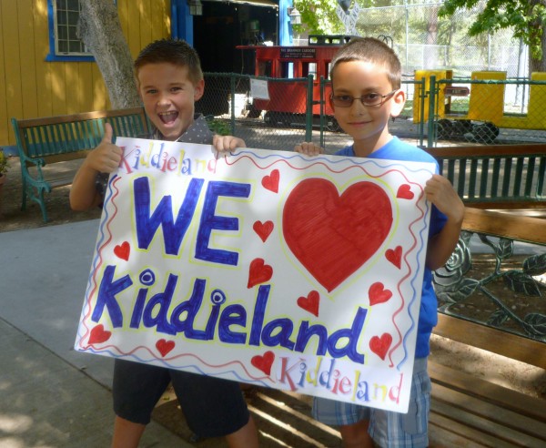
Kiddieland in the Applegate Park next to the Merced Zoo
Kiddieland: Fun for the whole family!
Kiddieland hours of operation
Kiddieland is open to the public on weekends from 10 a.m. - 2 p.m. annually, usually from late March or early April through October with three exceptions; the park is closed on Easter Sunday, Mothers Day, and the weekend the Merced county fair is going on.
Plan a birthday party at Kiddieland
Kiddieland can be reserved for Birthday Parties from 10:30 am to 1:30 pm on Saturday or Sunday.
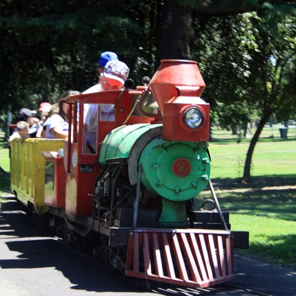
Kiddieland offers six rides:
The now famous train ride
Car ride
Merry-Go-Round
Helicopters
Rocket Ships
Go-Gator Roller-coaster
Kiddieland also has a convenient snack bar available offering a reasonably priced assortment of family favorites.
Bring your kids and grandkids
The whole family will enjoy Kiddieland in Applegate Park next to the Merced Zoo. Plan a visit and have fun at the Merced Zoo along with a picnic in the Applegate Park.
Kiddieland is operated by the Kiwanis Club of Greater Merced. Click here for more information.


State Parks and State Recreation Areas in Merced County
Los Banos Creek - Photo by adam blauert
Merced County boasts state parks and state recreation areas. They provide river access, campgrounds, picnic facilities, swimming, boating, fishing, water recreation, OHV recreation, and trails for hikers, bikers and equestrians. These parks include:
George J. Hatfield State Recreation Area
Great Valley Grasslands State Park
McConnell State Recreation Area
PHOTO BY ADAM BLAUERT
George J. Hatfield State Recreation Area: This state park has a mile of river frontage and plenty of shade. It’s proximity to the road and the poor condition of some of its facilities make it less favorable than some of the other parks on the river, but it still provides many excellent fishing opportunities. Near the park is a historic bridge over the Merced River. Built in 1910, it is now open only to pedestrians and bikers. It provides nice views of the river.
Location: 4394 North Kelly Road, Hilmar, CA
Distance from Merced: 30 miles
Distance from Los Banos: 29 miles
Size: 46.5 acres
Facilities and activities:
Flush restrooms
Drinking fountains
Campgrounds/group campgrounds with BBQ grills/fire rings
Picnic areas with tables, shelters, and BBQ grills
Group picnic areas
Swimming area
Dogs allowed? Yes
Horses allowed? No
Hunting allowed? No
Fishing or boating? Fishing can be good at George J. Hatfield Recreation Area. Rainbow trout and bass can be caught in the spring; catfish and perch throughout the year. No boating ramp is provided, but it is possible to swim in the river or to launch a float tube or hand-carried boat.
Website: http://www.parks.ca.gov/?page_id=556
and http://www.parks.ca.gov/pages/554/files/McConnellHatfield.pdf
Nearby Parks: Undeveloped Great Valley Grasslands State Park has a six mile hiking trail.
Great Valley Grasslands State Park: This park preserves one of the few remaining examples of Central Valley grassland. The primary attraction of this undeveloped park is a six mile loop trail along levee roads. Along this route you can see, the San Joaquin River, native bunchgrass prairie, and vernal pools.
Location: The park’s entrance is on Highway 165 (Lander Ave) just south of Highway 140
Distance from Merced: 21 miles
Distance from Los Banos: 19 miles
Size: 2,700 acres
Facilities and Activities:
Hiking/biking trails
Wildlife viewing
Dogs Allowed? No
Horses Allowed? No
Hunting Allowed? No
Fishing or Boating? No boat ramps are provided, but float tubes could be launched in the San Joaquin River. Bass and catfish are the primary species caught in this area.
Website: http://www.parks.ca.gov/?page_id=559
and http://www.parks.ca.gov/default.asp?page_id=25155 for trail description
Nearby Parks: Camping and picnic areas are available at George J. Hatfield State Recreation Area, McConnell State Recreation Area, and San Luis State Recreation Area. Picnic areas are also available at Hagaman County Park.
McConnell State Recreation Area: Like the other Merced River Parks, McConnell has a lot of shade. It’s also a bit more developed than Hatfield and further from the highway. If I were to pick a Merced River park in the Valley to camp at, this would be it.
Location: 8800 McConnell Road, Ballico, CA
Distance from Merced: 22 miles
Distance from Los Banos: 35 miles
Size: 74 acres
Facilities and activities:
Flush restrooms
Drinking fountains
Campgrounds/group campground with BBQ grills/fire rings, hot showers
Picnic areas with tables and BBQ grills
Group picnic area
Swimming area
Dogs allowed? Yes
Horses allowed? No
Hunting allowed? No
Fishing or boating? Fishing can be good at McConnell Recreation Area. Rainbow trout and bass can be caught in the spring; catfish and perch throughout the year. No boating ramp is provided, but it is possible to swim in the river or to launch a float tube or hand-carried boat.
Website: http://www.parks.ca.gov/?page_id=554 and http://www.parks.ca.gov/pages/554/files/McConnellHatfield.pdf
Nearby parks: Undeveloped Great Valley Grasslands State Park has a six mile hiking trail.

Pacheco State Park: This park preserves part of a large Mexican land grant given to the Pacheco family in 1843. 28 miles of trails are available for hiking, biking, and equestrian use. Thousands of acres of gently rolling oak woodland produces spectacular wildflower displays in the spring. The ruins of the Pacheco Adobe and a well-preserved line shack from Henry Miller’s ranching operation stand near the picnic area.
Location: 38787 Dinosaur Point Road, Hollister, CA. Accessed from Highway 152.
Distance from Merced: 59 miles
Distance from Los Banos: 23 miles
Size: 6,890 acres
Facilities and Activities:
Chemical/flush restrooms
An equestrian campground is available for special events; other campgrounds are available at the adjacent San Luis State Recreation Area
Picnic areas with tables
28 miles of hiking/biking/equestrian trails
Wildlife viewing
Wildflower viewing
Dogs Allowed? In picnic area, but not on trails
Horses Allowed? Yes
Hunting Allowed? No
Fishing or Boating? No
Website: http://www.parks.ca.gov/?page_id=560 and http://www.parks.ca.gov/pages/560/files/Pacheco.pdf. See http://www.parks.ca.gov/pages/560/files/PachecoTrailMap2006small.pdf for a trail guide.
Special Events: Ranger-led wildflower hikes in the spring. A kite flying day is also held annually.
Nearby Parks: Camping is available at the adjacent San Luis State Recreation Area

Photo by adam blauert
San Luis State Recreation Area
(San Luis Reservoir, O’Neill Forebay, Los Banos Creek Reservoir):
The San Luis State Recreation Area is made up of three units. San Luis Reservoir is the largest and is used primarily for fishing. Part of both the California Aqueduct and the Central Valley irrigation projects, it is the largest off-stream reservoir in the United States. At full capacity, it measures nine by five miles at its widest points.
The O’Neill Forebay, a smaller lake below the San Luis Dam, is open to all kinds of recreation and offers the best fishing in the area. Although this area can be windy, the O’Neill Forebay is more sheltered than the San Luis Reservoir. O’Neill Forebay is considered to be one of California’s premier fishing areas. The State record striped bass was caught in O’Neill Forebay in 2008. It measured 52.5 inches and weighed 70.6 lbs.
Los Banos Creek Reservoir, located a few miles to the south, receives much less visitation. It is best-known for springtime ranger-led hikes along the creek in the spring. With a 5mph speed limit, Los Banos Creek Reservoir is primarily enjoyed by anglers. A shoreline trail is provided for fishing access.
Location: San Luis Reservoir and the O’Neill Forebay are located on Highway 152, a few miles west of I-5. Additional access is available from State Highway 33. Los Banos Creek Reservoir is located on Canyon Road, southwest of Los Banos and I-5.
Distance from Merced:
San Luis Reservoir and O’Neill Forebay: 48 miles
Los Banos Creek Reservoir: 42 miles
Distance from Los Banos:
San Luis Reservoir and O’Neill Forebay: 12 miles
Los Banos Creek Reservoir: 6 miles
Operating authority: California State Parks
Surface area of lake: San Luis Reservoir 12,700 acres
O’Neill Forebay 2,250 acres
Los Banos Creek Reservoir 623 acres
Facilities and activities:
Boat ramp
Chemical/flush restrooms
Drinking fountains
Visitor center
Campgrounds/group campgrounds with BBQ grills/fire rings, shelters, hot showers
Picnic areas with tables, shelters, and BBQ grills
Group picnic areas and shelters
Swimming beach/area with showers
Dump station
Hiking trails (additional trails available in the adjacent Pacheco State Park)
Wildlife viewing areas
OHV recreation area (south side of Highway 152 at Jasper-Sears Road. Novice-level trails for both green and red sticker vehicles are provided)
Dogs allowed? Yes
Horses allowed? Yes, and many equestrian trails are available at the adjacent Pacheco State Park.
Hunting allowed? Yes
Fish species:
San Luis Reservoir and O’Neill Forebay: bass, bluegill, crappie, perch, shad
Los Banos Creek Reservoir: bass, bluegill, catfish, and crappie. Trout are stocked in the early spring, but don’t last through the summer because of water temperatures.
Boat rentals: No
Website: http://www.parks.ca.gov/?page_id=558 and http://www.parks.ca.gov/pages/558/files/sanluisSRA.pdf
Special events: O’Neill Forebay hosts a Kids Fishing Day in the spring. The popular Path of the Padres is a Ranger-led hike along Los Banos Creek that is offered from February through April. Hikers enjoy a creekside walk through wildflowers and learn about the history, wildlife, and plant species of the area.
Nearby parks: Pacheco State Park is adjacent to San Luis Recreation Area and offers hiking and equestrian trails. Ranger-led wildflower hikes are offered in the spring.
The California Aqueduct Bikeway begins at San Luis Creek and goes 70 miles north to the Bethany Reservoir State Recreation Area with rest stops ten miles apart and chemical toilets.
Turlock Lake State Recreation Area: Less than an hour from many points in Merced County, Turlock Lake large and easily accessible.
Location: Lake Road (accessed from Highway 132) between Waterford and La Grange
Distance from Merced: 32 miles
Distance from Los Banos: 67 miles
Operating authority: California State Parks
Surface area of lake: 3,500 acres
Facilities and activities:
Boat ramp
Flush restrooms
Drinking fountains
Campgrounds with BBQ grills/fire rings, hot showers
Picnic areas with tables, shelters, and BBQ grills
Swimming beach
Short hiking trails
Dogs allowed? Yes
Horses allowed? No
Hunting allowed? No
Fish species: bass, bluegill, catfish, crappie, trout
Boat rentals: No
Website: http://www.parks.ca.gov/?page_id=555 and http://www.parks.ca.gov/pages/555/files/TurlockBrochure1.pdf
Other Resources:
Fishing and Boating Resources at http://www.takemefishing.org/
Department of Fish and Game Regulations: http://www.dfg.ca.gov/
Department of Boating and Waterways Regulations: http://www.dbw.ca.gov/
Reservations for State, Federal, and Army Corps of Engineers Campgrounds: http://www.reserveamerica.com

Fishing and Floating the Merced River
The Merced is our local river and it can be a great place to fish or float. Because access points aren’t well publicized, this page is an attempt to provide some information about them.
Starting in the high country of Yosemite National Park, the river flows westward for 145 miles before joining the San Joaquin near the town of Newman. The following is a list of access points in Merced County starting at the western end of the river and working east towards Mariposa County.
Safety:
Fishing is generally a safe river recreation as long as you do not wade out into the river.Swimming, boating, and floating the river on rafts or tubes are more hazardous activities.They are not recommended except in designated swimming sites such as the Hatfield and McConnell State Recreation Areas.Do not venture out into the river unless you are a strong swimmer, you wear a life jacket, you are sober, and you have a first aid kit and plenty of emergency supplies.
If you’ve never floated a river before, find someone experienced to go with.
The river has several rapids and places where rafters and boaters may be swept into trees and vines.There are also places where the river splits into multiple channels and it can be difficult to choose the safest route.High water flow, especially in the spring and after storms, may make the river extremely dangerous.Mid to late summer is usually the safest time to go, but this is not always the case.
Rivers have dangerous underwater hazards that can snare and drown swimmers and boaters.Every year California’s rivers claim lives!Think carefully before getting in the river and observe any posted safety warnings.
Some of the best online information about floating the river can be found at:https://www.americanwhitewater.org/content/River/detail/id/5042/.
Access Points:
George J. Hatfield State Recreation Area: Located near the river’s confluence with the San Joaquin, this state park offers the last access point to the river.Camping, picnicking, fishing, wading, and swimming are all permitted.Located at 4394 North Kelly Road which is technically in the town of Hilmar, the closest population center and supplies is actually Newman.

Photo by Adam Blauert
For more information go to http://www.parks.ca.gov/?page_id=556.
A brochure that covers both Hatfield and McConnell State Recreation Areas can be downloaded at:
http://www.parks.ca.gov/pages/554/files/McConnellHatfield.pdf
You can also call the park office at (209) 826-1197 for more information.
Hagaman Park/Highway 165:
The signs posted by Merced County at Hagaman Park tell visitors that they should stay out of the river, but the brochure produced by California State Parks to provide information about its two parks along the river (Hatfield and McConnell) lists it as one of the places you can take your raft or canoe out of the river if you are floating it.
The result is confusion.I don’t recommend Hagaman Park as a place to access the river, but if you are interested in doing so, contact Merced County Parks and Recreation first: (209) 385-7426.

Photo by Adam Blauert
You can also find park information at http://www.co.merced.ca.us/index.aspx?NID=1410.
Hagaman Park is located at the intersection of Highway 165 (Lander Avenue) and River Road.Highway 165 crosses the river and all potential access points near the highway are marked “No Trespassing.”
McConnell State Recreation Area:
This state park offers camping, picnicking, and some of the best access for fishing, wading, and swimming on the lower river.Located off El Capitan Way at the end of McConnell Road, the closest population centers and supplies are Delhi and Livingston.
For more information, go to http://www.parks.ca.gov/?page_id=554.
A brochure that covers both McConnell and Hatfield State Recreation Areas can be downloaded at:
http://www.parks.ca.gov/pages/554/files/McConnellHatfield.pdf
You can also call the park office at (209) 394-7755 for more information.
Bridges:
Highway 99 Bridge:All potential access points along the highway are marked “No Trespassing.”
Santa Fe Avenue Bridge: Like Highway 99, all potential access points along the highway are marked “No Trespassing.”
Oakdale Road Bridge:There’s plenty of parking near the bridge and you can walk across the original 1912 bridge (now only open to foot and bike traffic), but the potential river access points are signed “No Trespassing.”It’s clear that some people do access the river here, but you’re liable to citation for trespassing if you do.
Highway 59 Bridge: Although official signs at this location delineate the fishing regulations for this part of the river, the landowner has informed me that any access at this point will be considered trespassing. Don’t access the river at this location."
Snelling Road Bridge:Like the Highway 59 Bridge, land on both sides is private, but access has been allowed from the corridor along the highway.If you access the river here, be aware of all posted signs which may limit access in the future.The bridge is located on Snelling Road, 0.7 miles south of the junction with Highway 59.
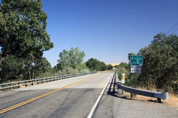
Photo by Adam Blauert
Snelling:
I’ve talked to a lot of people who have fished the river at the end of 3rd Street in Snelling, but there are currently “No Trespassing” signs posted.If you visit, check the signs before you access the river.
This area is accessed by turning south on 3rd Street (near the Chevron gas station) and following the road for a short distance.It becomes a rough dirt road near the river.

Photo by Adam Blauert
Henderson Park:
This county park is located 1 mile east of downtown Snelling on Merced Falls Road.It offers picnic areas, playgrounds, and plenty of river access.Signs warn visitors about the dangers of river access, but do not prohibit it.

Photo by Adam Blauert
For more information go to http://www.co.merced.ca.us/index.aspx?NID=1454
or call (209) 385-7426. This is one of the most picturesque spots on the lower river. A $3/car entry fee is charged on weekends and holidays.
Other access points
First access point east of Snelling: Set your odometer to zero at the intersection of 3rd Street and Highway 59 in Snelling. Highway 59 becomes Merced Falls Road at the junction with County Highway J59. The second access point to the river is 1.6 miles beyond 3rd Street and Highway 59. After you pass the J59 junction and Henderson Park, look for the first yellow sign indicating a left curve. There is a small parking area and a sign indicating fishing regulations on the right side of the road.
MID Cuneo Access:Located at mile 2.5, you will see a sign, a fenced gravel parking lot, and a restroom. The river is a short walk from the parking area along a trail.This access point may be closed seasonally, even when fishing is allowed.
Access between Cuneo and Crocker Huffman:At mile 3.3 begins a series of parking areas along the bank of the river to mile 3.6. The first one is located by an electrical pole and mailboxes for 5706 and 5996 Merced Falls Road. The parking areas end across from a sign indicating the entrance to 5996 on the left side of the road.These areas have been “No Stopping Any Time,” since Summer 2014 due to litter and traffic problems.According to Merced County, you can stop briefly to drop off fishing gear or rafts, but then must move your vehicle beyond the signs.
MID is currently constructing a new parking and access area that should be opening just east of this access point.The estimated opening date is sometime later in 2015.
MID Crocker-Huffman Fishing Access:After a 40 mph curve, you’ll see a fenced gravel parking lot and a sign indicating MID ownership at mile 4.1. If you pass A-1 Bait and Tackle, you’ve driven too far. A hike of about ¼ mile from the parking area will take you to the dam. Note that fishing regulations are different for the area above the dam and the area below. Consult the DFG’s fishing regulations to make sure that you are in compliance.This access point may be closed seasonally, even when fishing is allowed.
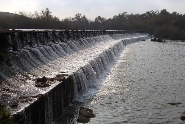
Photo by Adam Blauert
PG&E River’s Edge Fishing Access:This access point is 6.2 miles beyond Snelling, next to the PG&E hydroelectric plant. This access point allows you to fish above the spillway of the Merced Falls Dam. Note that swimming, float tubes, and boats are not allowed because of the proximity to the dam.
Hornitos Road Bridge Area:After Merced Falls Road turns sharply north, make a right turn on Hornitos Road. Turn again when the road splits for Lakes McSwain and McClure (left) and Hornitos Road (right). There are a number of places to park near the bridge. This area is 6.4 miles from 3rd and Highway 59 in Snelling. This is a popular place to fish from the shore or to launch float tubes or canoes.

Photo by Adam Blauert
PG&E Lake McClure Road Access:7.2 miles east of Snelling on Lake McClure Road, a right hand turn just before you reach the entrance gate to Lake McSwain and Lake McClure Recreation Area leads to another PG&E access point directly below the Lake McSwain Dam.

Photo by Adam Blauert
Mariposa County Access:
Beyond the McClure Road access point, the river is a part of Lakes McSwain and McClure. It becomes a free-flowing river again at the eastern end of Lake McClure where it is crossed by the Highway 49 Bridge.There is no road along the next 8.4 miles of the river.A very rough trail follows it (washed out on the Highway 49 side) but you can follow it cross-country on the northern side of the river until it becomes a true trail again.The eastern side of the trail is accessed from the end of the Briceburg Road.
There is no bridge across the confluence of the North Fork of the Merced, which can only be waded safely in low water conditions.The Briceburg Road follows the next 5 miles of the river beyond the trail up to where it joins Highway 140.From that point onwards, Highway 140 parallels the river closely into Yosemite National Park.
There are many views of the river from the road and many places to fish.Floating the river above Lake McClure is not recommended as there are many dangerous class III-IV rapids and a small waterfall near the confluence of the North Fork.
Rafting services
Several whitewater rafting companies offer guided trips to this area:
ARTA:Merced/Tuolumne - http://www.arta.org// (209) 962-7873
All-Outdoors California Whitewater:Merced/Tuolumne/Stanislaus/Cherry Creek - http://www.aorafting.com// (800) 247-2387
O.A.R.S.:Merced/Stanislaus/Tuolumne - http://www.oars.com/california/ (800) 346-6277
Whitewater Voyages:Merced/Tuolumne - http://www.whitewatervoyages.com/(800) 400-7238
Zephyr Whitewater:Merced/Tuolumne - http://www.zrafting.com/
From the end of the road in Yosemite, trails follow the river past Vernal and Nevada Falls to its sources in the wilderness of the park.
Avoiding Trespassing:The safest spots for legal river access in Merced County are Hatfield, McConnell, Henderson, and the access points maintained by MID and PG&E. The others are privately owned, but have not been posted or fenced in the past (this is always subject to change). This seems to indicate that the landowner is allowing access, however you may risk trespassing if you access the river at these points.
Taking Care of the River: Unfortunately, several of these access points have been trashed by previous users. Despite the work of volunteers to clean up the garbage, the problem continues. If the situation doesn’t improve, more access points may close or be posted “No Trespassing.”
Make sure you pack out your garbage and do anything you can to help keep these areas clean.

Photo by Adam Blauert
Fishing Regulations:Make sure you check fishing regulations for the area in which you plan to fish:http://www.dfg.ca.gov/. They change at the Crocker Huffman Dam.Although they are usually posted at the areas between the dam and the Highway 59 Bridge, conditions are always subject to change and may not be posted.
Other fishing and boating resources:
Fishing and Boating Resources at http://www.takemefishing.org/
Department of Fish and Wildlife Regulations: https://www.wildlife.ca.gov/
Department of Boating and Waterways Regulations: http://www.dbw.ca.gov/
Reservations for State, Federal, and Army Corps of Engineers Campgrounds: http://www.reserveamerica.com
The goal of this page is to provide useful and accurate information about river access. If you find something that is inaccurate or discover that conditions have changed, please inform the author atadamblauert@yahoo.com

Merced's Central Park: Applegate Park, Zoo & Kiddieland Merced

flag in park
Applegate Park is Merced’s central park
Located along the Bear Creek Bikeway, the park is an excellent destination on bike or foot. It offers 32 acres of recreation with a zoo, outdoor theater, picnic tables, bbq grills, volleyball nets, tennis/basketball courts, a skate park, rental facilities, a large playground, a rose garden and fountain, and the Kiwanas-sponsored Kiddieland amusement park.
train
Plenty of parking is located around the park. Many community events are held at Applegate, including concerts and plays in the summer.

fountain
Location
Applegate Park is located along Bear Creek and the Bear Creek bikeway, between M and R Streets. The southern edge of the park follows 25th Street, P Street, and 26th Street.
Parking is available along the southern edge, N Street, and a parking lot on R Street near the Zoo.
applegate
Applegate Park Zoo
Merced Open Air Theater
Sports Facilities (Tennis, Basketball, Volleyball)
Skatepark
Playground
Fitness Equipment
Rental Facilities
playground

zoo 1
Applegate Park Zoo
The zoo specializes in local wildlife and activities for children, showcasing species native to the Central Valley and the foothills. From commonly-seen birds such as egrets and hawks to the elusive mountain lion, the zoo offers a cross-section of native wildlife.
Most of the animals have been relocated from wildlife rescue agencies.
Although owned by the City of Merced, the zoo is operated by the nonprofit Merced Zoological Society.

zoo 2
Friendly, trained volunteers are available to answer questions. This is a great place to get a close-up view of local species before heading out to a nearby wildlife refuge.

zoo 3
Hours and Admission
The zoo is open from 10-5 daily in the spring and summer and from 10-4 in the fall and winter, weather permitting. The zoo is closed on Thanksgiving, Christmas, and New Year’s Day.
For the latest Zoo hours and cost for admission, click here
Location
The zoo is located on R Street between Bear Creek and 25th Street. A parking lot is located on the corner of R and 25th.

goats
Activities
Petting Zoo and Goat Feeding: Friendly (and hungry) goats can be fed with goat food for sale at the zoo’s gift shop until the day’s supply runs out. Visitors who wish to feed the goats are advised to visit before 2PM.
The zoo also offers a small petting area where kids can play with chickens, rabbits, ducks, kittens, turtles and guinea pigs.
Field Trips: The Merced Zoological Society can arrange guided visits to the zoo for school groups.
Zoo Camp and Special Events: The zoo holds two one-week zoo camps for children aged 6 to 9 and a “Trick or Treat in the Zoo” on Halloween.
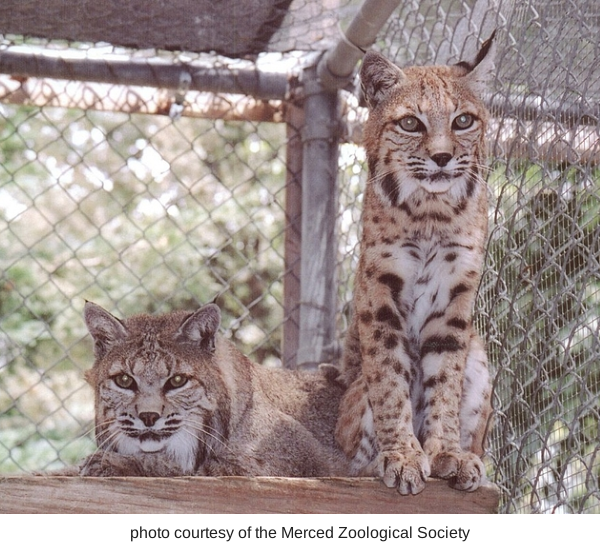
bobcats
Sometimes it is the "small animals" that are fun for the little ones!
This is a safe and fun option for families with small children. A storytime for kids aged 3-5 is offered every Saturday from 11-12. A number of other special events happen throughout the year.

savana
Birthday Parties
The zoo can be rented for birthday parties. Facilities include the Rossotti Ed-Zoo-Cation Center building with tables, chairs, refrigerator, freezer, and silverware. Table coverings, napkins, plates, cups, and invitations in an animal theme design are provided.
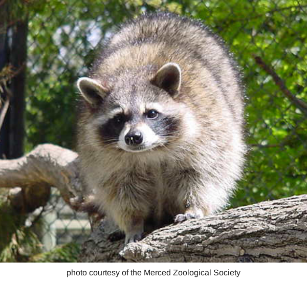
racoon
Zoo Parent Adoption Program
Groups can participate in the Zoo Parent Adoption Program which allows them to help feed and care for the zoo’s animals.
Gift Shop
The Zoological Society operates a gift shop that specializes in educational toys, books, and gifts. All proceeds help support the zoo’s operations.
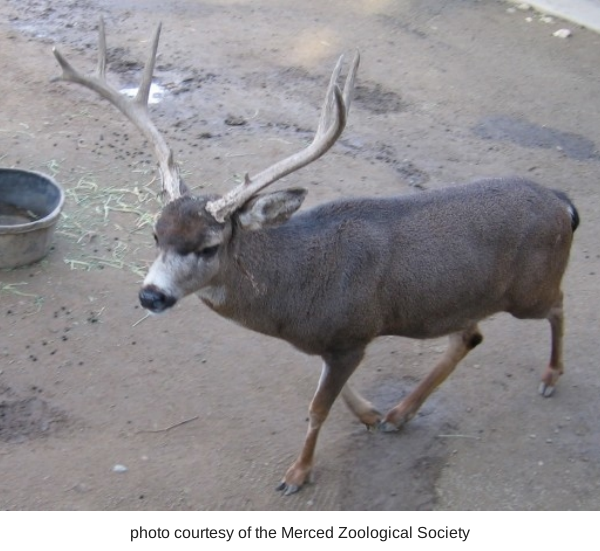
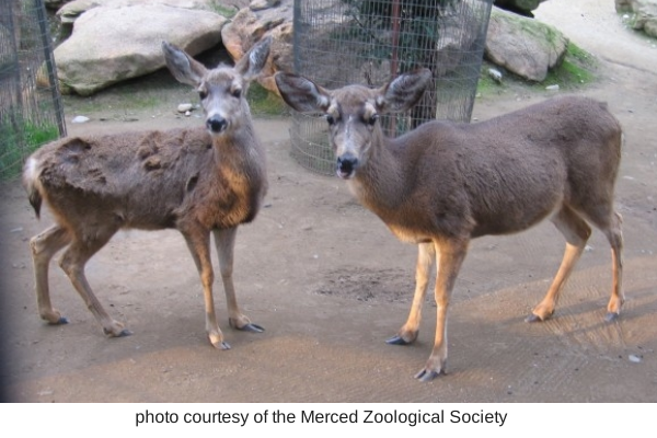
buck
Species
Mammals: black bear, mule deer, bobcat, raccoon, red fox, silver fox, opossum, goat, capuchin monkey
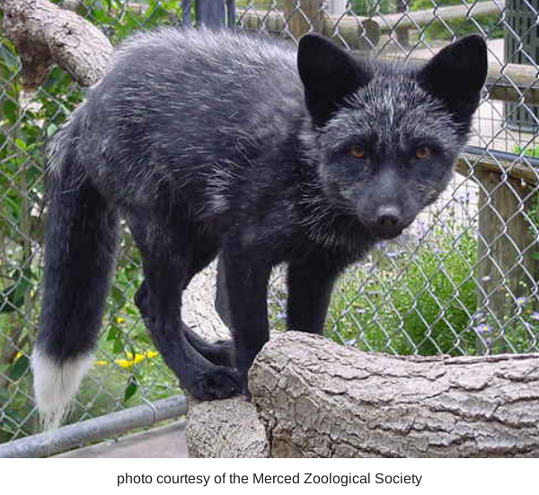
fox

screach owl
Birds: albino scrub jay, black crowned night heron, black swan, burrowing owl, cattle egret, emu, great egret, great snowy egret, green heron, great horned owl, harrier hawk,

owl
deer
ibis, kestrel, killdeer, magpie, northern flicker, peacock, raven, red tailed hawk, snowy egret, screech owl, Swainsons hawk, wild turkey, whistling (tundra) swan, wimberl, white faced ibis
Reptiles: tortoise, turtle
City of Merced- Applegate Zoo info (click here)
or contact the Merced Zoological Society at Mercedzoological@sbcglobal.net /
(209) 725-DEER (725-3337)
Kiddieland: Merced Kiwanis
Oporates the local Kiddieland amusement park since 1957. With six rides including a train that loops around Applegate Park, Kiddieland is a great place to take children on weekend afternoons.
Friendly Kiwanis volunteers operate the rides on Saturdays and Sundays from 1-5PM starting in March of each year.

Kiddieland 1
The amusement park remains open through October. Snacks are available at a refreshment booth. Kiddieland can be also be rented for private parties.
For more information about Kiddieland, click here
Location: Near the intersection of 25th and Q Streets.

Kiddieland 2
Additional information: Check out the Kiwanis webpage at http://greatermercedkiwanis.org/kiddieland Kiwanis is a worldwide volunteer organization whose motto is “serving the children of the world.”
Merced Open Air Theater
The most popular outdoor entertainment venue in Merced County, the Open Air Theater is the site of free concerts and plays throughout the summer. The theater can be rented for private events. Visit the City of Merced’s webpage for rental information: City of Merced Rental information.

Open Air Theater
Merced Shakespearefest stages Shakespeare plays at the Open Air Theater every summer. For more information go to: http://www.mercedshakespearefest.org/index.htm
Location: The theater is located in the middle of the park along the bikeway.
Sports Facilities
Volleyball nets are located in the eastern half of the park, between M and O Streets.
Tennis and basketball courts are located in the center of the park, near Kiddieland.
Skatepark: The skatepark is located in the center of the park, near O and 26th Streets.

Skatepark
Bikeway: Applegate Park is located along the Bear Creek Bikeway, which runs from McKee Road to Highway 59.
This route connects with other bikeways and bike lanes in Merced.
For a map, go to http://www.cityofmerced.org/documents/bikepathmap.pdf
Also check out our page titled Bike Paths in Merced County for additional bike routes throughout the county.
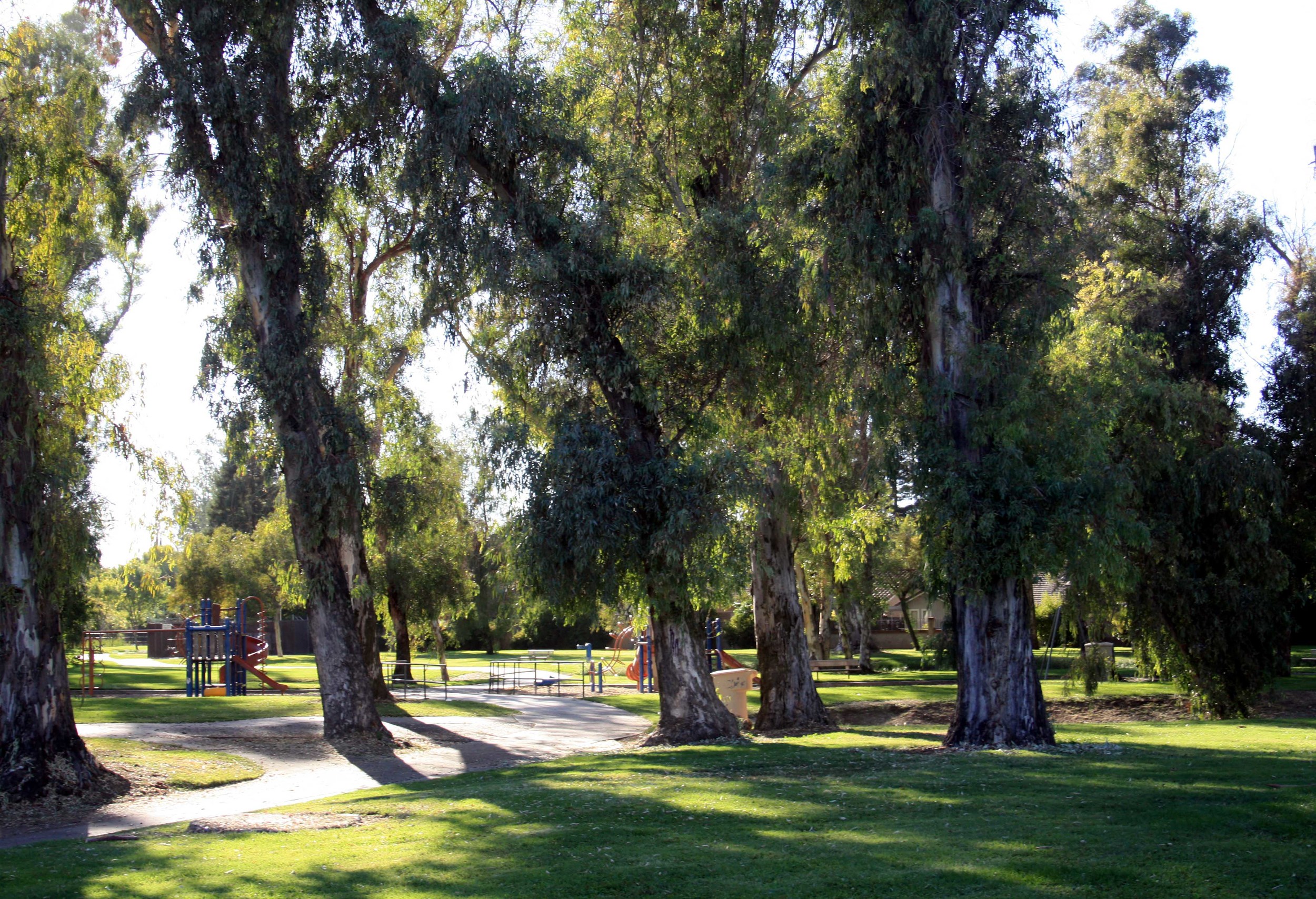
Playground: A large playground is located in the center of the park along 25th street between Q and P Streets. The playground includes swings, a large climbing structure with slides, and benches.
Rental Facilities: The Rossotti Ed-Zoo-Cation Center, Merced Open Air Theater, Scout Hut, Picnic Shelters, Gazebo and Rose Garden can all be rented for group events.
Visit the City of Merced’s webpage for rental costs and forms: City of Merced Rental information.

Visit Hagaman Park-Merced County
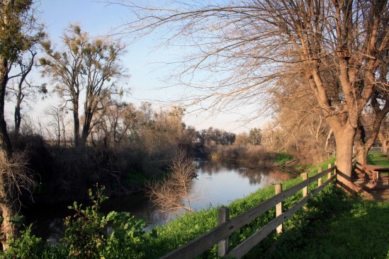
Photo by adam blauert
Hagaman Park
Located on a bluff above the Merced River in northwestern Merced County, Hagaman Park is especially popular with residents of the west side of the county. A large picnic area is available for rent.
Because of drownings, this area is not open to fishing and a fence runs along the bluff to discourage river access.
If you want to swim or fish in the Merced River, try George J. Hatfield State Recreation Area, or McConnell State Recreation Area.
Location
19914 River Road, Stevinson, CA (Intersection of River Road and Highway 165)
Distance from Merced: 24 miles
Distance from Los Banos: 23 miles
Facilities and activities
Flush restrooms
Drinking fountains
Picnic areas with tables, shelters, and BBQ grills
Group picnic areas and shelters
Playground
Hagaman Park
Website
Nearby Parks
Camping and picnic areas are available at

Local Performing Arts

Photo by adam blauert
Local Valley performing arts
Within Merced County and an hour’s drive there are lots of venues to enjoy a wide range of performing arts and classic films.
(For information on local art venues, click on these links for the Merced Multicultural Arts Center and Turlock’s Carnegie Arts Center).

Playhouse Merced- PHOTO BY ADAM BLAUERT
Playhouse Merced
Since 1994, Playhouse Merced has offered a wide range of musical and non-musical productions that include new shows, classics, and pieces written for children and families.
Averaging over 12 productions a year, it’s a great place to enjoy performances by members of our community and by visiting artists. Performances are generally staged with the audience seated on three sides of the stage, close to the action.
The theater is located in downtown Merced, near Bob Hart Square.
For more information go to http://www.playhousemerced.com/index.html
or call (209) 725-8587.
Merced Theatre
After a complete restoration to its 1931 movie palace grandeur, the Merced Theatre reopened in 2012. It now regularly features live music, comedy, classic films, community productions, and the Merced Symphony (http://www.mercedsymphony.org/index.html / 209-383-3277).
For more information about the theatre go to
http://www.mercedtheatre.org/ or call 209-381-0500.
The Merced Shakespearefest
(http://www.mercedshakespearefest.org/ /
209-723-3265) performs at both the Merced Theatre and the open air theatre in Applegate Park.
Merced College’s Theatre Department
also offers drama, music, dance, and travelogues throughout the year.
For more information and for a schedule of current and upcoming performances, go to:http://www.mccd.edu/thearts/ or call (209) 386-6644.
CSU Stanislaus’ Department of Music
presents recitals and concerts throughout the year at the college’s Turlock campus. The Theatre Department also offers a variety of dramatic performances.
For music information go to http://www.csustan.edu/soa/musictickets.html
and for drama go to http://www.csustan.edu/soa/theatretickets.html.
You can also call (209) 667-3959 for information about both.
The Turlock Community Theatre
Hosts a wide range of national and local musicians and comedians throughout the year (http://turlocktheatre.org/index.html /
(209) 668-1169).
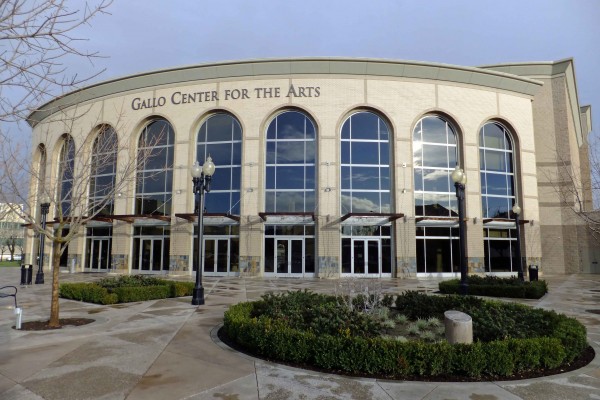
Gallo Center - PHOTO BY ADAM BLAUERT
Gallo Center
Modesto’s premiere performing arts venue is the Gallo Center, featuring nationally-known musicians, drama, and comedy.
Two years ago, I enjoyed seeing Hal Holbrook (86 years old at the time!) perform his one-man Mark Twain Tonight! show here. That’s the kind of talent that the Gallo Center attracts.
It’s also home to the Modesto SymphonyOrchestra (http://www.modestosymphony.org/ / 209- 523-4156) and the Townsend Opera (http://townsendopera.com/ / 209-523-6426).
For more information about the Gallo Center go to http://www.galloarts.org/
or call (209) 338-2100.
Modesto’s historic art deco State Theatre
Offers both live performances and classic films (http://www.thestate.org/ 209-527-4697).
MJC
The students and faculty of Modesto Junior College regularly present dramatic, musical, and dance performances (http://www.mjc.edu/general/news/eventstix.html / 209-575-6776).
West Side Theatre
West of Modesto, Newman’s historic West Side Theatre features a wide range of regional and national music talent (http://www.westsidetheatre.org/ /
209-862-4490).
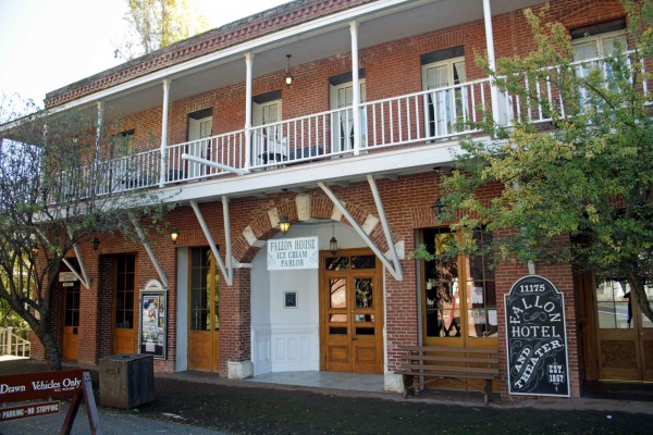
Fallon House Columbia - PHOTO BY ADAM BLAUERT
Columbia
To the east, the Sierra Repertory Theatre offers performances in both the East Sonora Theatre and the historic Fallon House Theatre in Columbia State Historic Park (http://www.sierrarep.org/index.html 209-532-3120).
Fresno area
To the south, Fresno boasts a wide range of performing arts options and venues. At the Fresno Convention Center, the Saroyan Theatre provides a large setting for traveling dramatic and musical performances, and for the Fresno Ballet Theatre (http://www.valleyperformingartscouncil.org/Site_4/Home.html),
Fresno Grand Opera (http://www.fresnograndopera.org/ or call 559-442-5649)
and Fresno Philharmonic (http://www.fresnophil.org/ / 559-261-0600). Also part of the Convention Center, Selland Arena hosts a wide range of events from basketball to Disney on Ice.
For more information about the Fresno Convention Center, go to http://www.fresnoconventioncenter.com/.
Also in downtown Fresno, the Warnors Theatre hosts live music and historic silent films accompanied by live organ music (as they were often originally shown in the early 1900’s). For more information go to http://www.warnors.org/ or call (559) 264-2848.
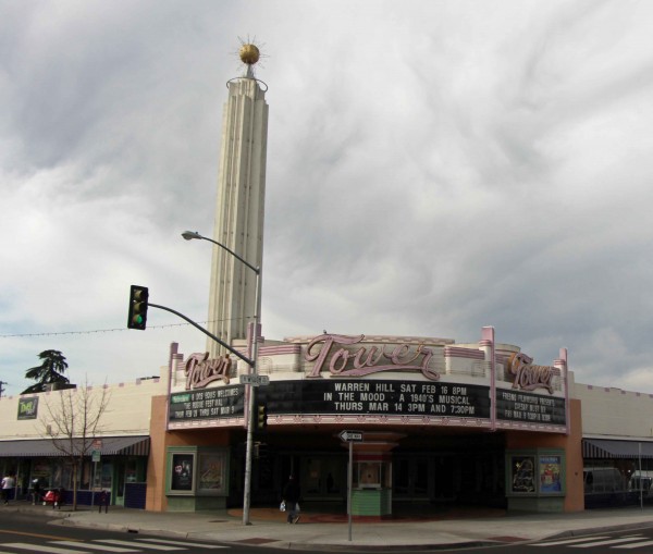
Tower Theatre - PHOTO BY ADAM BLAUERT
In Fresno’s Tower District, the historic art deco Tower Theatre also offers dramatic performances, music, and comedy (http://www.towertheatrefresno.com/ / 559-485-9050).
Roger Rocka’s Dinner Theater presents classic musicals paired with excellent food http://rogerrockas.com/ / (559-266-9494).
Fresno’s Save Mart Center is part of Fresno State University. It features large-scale concerts and sporting events.
Major national and international talent is often seen here performing for large crowds. Andrea Bocelli performed at Center’s opening and upcoming shows include Tim McGraw, Lady Antebellum, and Bruno Mars.
For more information go to http://www.savemartcenter.com/
or call (559) 347-3400.
Fresno State’s Theatre Department presents regular concerts, dramatic productions, and dance performances on the university campus (http://www.fresnostate.edu/artshum/theatrearts/ / 559-278-2216).
Fresno City College offers a wide range of dramatic performance, music, and dance – including the annual City Jazz Festival ( http://www.fresnocitycollege.edu/index.aspx?page=1719 / 559-442-8221).
Until I started compiling this list of performing arts venues, I really didn’t realize how many options were so close to home. There’s a lot to enjoy without driving a long distance!
Note to parents
Unlike movies, live theatre doesn’t always come with “mature content” warnings.
Always check the suitability of a performance before planning a family outing. We had a few surprises during my growing up years!
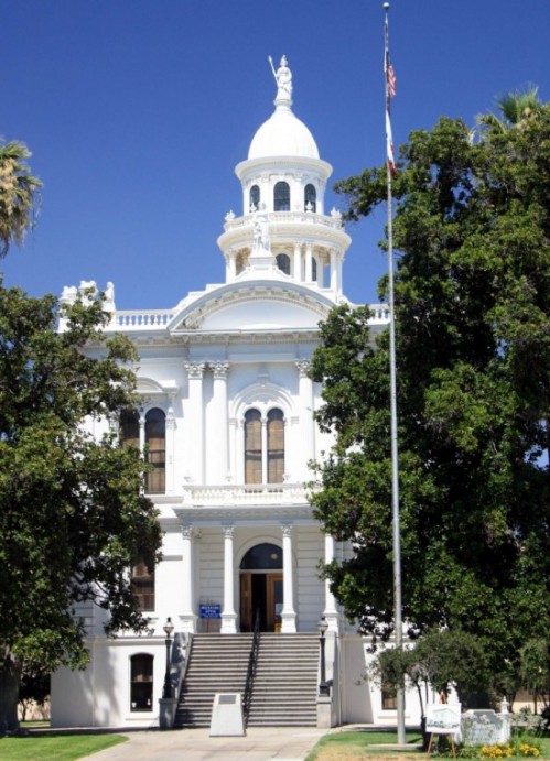
Merced County Historical Society Museum

photo by adam blauert
Merced County Historical Society Museum
Merced County’s history comes to life in the museum operated by the Merced County Historical Society. Housed in the 1875 Italianate-style courthouse, over 8,500 square feet of permanent and rotating exhibits tell of the history and development of the county.
One of the oldest and best-preserved buildings in the region, the old courthouse was designed by the state capitol architect Albert A. Bennett.
It is now on the National Register of Historic Places.
Exhibits
The museum’s displays cover the history of the county from ancient times to the present day including:
Yokut Indian artifacts
Displays of early ranching and farming, including a blacksmith shop
Artifacts from Merced’s Chinatown
A display of Merced County schools and a turn-of-the century classroom
“Old Betsy” – Merced’s first fire engine, built in 1859
The restored 1875 courtroom
Displays of home life in the later 1800’s through early 1900’s
Hours and Admission
The museum is open Wednesday through Sunday from 1-4. Admission is free and knowledgeable docents are available to provide tours. The building is wheelchair accessible.
Location
21st and N Streets, Merced
Gift Shop
The gift shop sells a wide variety of books about local history, along with gifts and souvenirs.
Events
The Merced County Historical Society hosts a wide range of history-themed events throughout the year. Check the website for a current schedule.
Archives
The museum holds a large collection of county records. Appointments to access the collection can be made by contacting the museum’s office.
Contact Information
(209) 723-2401/ http://www.mercedmuseum.org/

Henderson Park

PHOTO BY ADAM BLAUERT
Henderson Park popular for picnics
Stretched along the bank of the Merced River in eastern Merced County, Henderson Park is shaded by tall trees and further back from the road than the facilities at Hagaman County Park or George J. Hatfield State Recreation Area.
Like McConnell State Recreation Area, it feels more distant and removed than it actually is.
The park is popular for picnicking, large gatherings, river recreation, and fishing. Three rental facilities are available, including an indoor clubhouse with kitchen and fireplace.
Although Merced County Parks and Recreation discourages swimming in county parks, swimming is not prohibited here. Warning signs are posted and any swimming you do is at your own risk.”
Location
Merced Falls Road, 1 mile east of Snelling Distance from Merced: 20 miles Distance from Los Banos: 55 miles
Facilities and activities
Flush restrooms
Drinking fountains
Picnic areas with tables, shelters, and BBQ grills
Group picnic/banquet facilities (indoor and outdoor)
Playground
Softball diamond
Horseshoe pits
Dogs allowed? No
Horses allowed? No
Hunting allowed? No
Fishing and boating
Fishing for rainbow trout is popular along the river and small boats can be hand launched from a concrete ramp (vehicles are not permitted near the ramp).
Nearby Parks: Camping is available at:
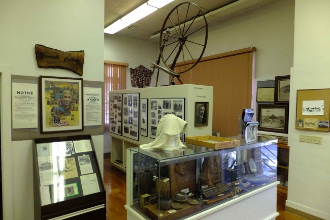
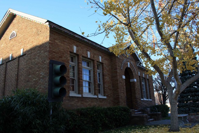
Livingston Historical Museum

photo by adam blauert
Livingston Historical Museum Foundation
On the northern edge of Merced County, the town of Livingston boasts an interesting historical museum.
It’s a great place to stop on a Sunday afternoon when it is staffed by members of the Livingston Historical Museum Foundation from 2 to 4 PM.
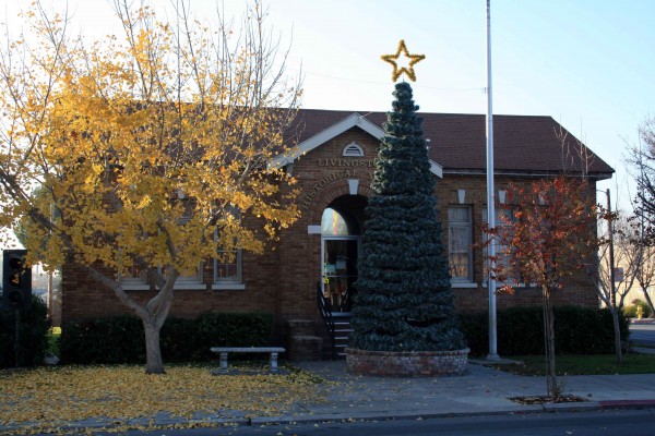
Museum at Christmas - PHOTO BY ADAM BLAUERT
Located on the corner of Main and C Streets in downtown Livingston, the museum’s collections are housed in a brick building that once served as the town’s city hall and courthouse.
David Livingstone
The town was named for Dr. David Livingstone, a British explorer of Africa who was an international celebrity in the late 1800’s. An error on the town’s Post Office application resulted in the difference in spelling between his name and the town’s.
Although the town’s original streets were laid out when the railroad arrived in the 1870’s, real growth began when irrigation water became available in the early 1900’s.
Like its neighbors Turlock, Hilmar, and Atwater, much of the settlement was accomplished through the colony system. Land speculators bought large tracts of land and then subdivided them and sold the subdivisions to farmers on credit.
These colony subdivisions were often marketed to specific ethnic groups through cultural networks and home-language periodicals. Best-known of these colonies was Yamato, settled by Japanese-Americans.
The museum has an excellent collection of photographs and artifacts from these early settlers. Their first years in the area were challenging, but hard work and determination ultimately led to success.
Internment camps
During WWII, prejudice and war hysteria led to the incarceration of 110,000 Japanese-Americans in internment camps throughout the western states. The museum has many examples of art created by the internees in the camps after they were forced to leave their homes.
One of the inspiring stories to come out of this sad time in our history is that of how the land and property of Livingston’s Japanese-American farmers was protected by a corporation formed by these farmers and placed under the control of a European-American lawyer.
Unlike most other Japanese-Americans, these farmers got most of their property back after they were released.
Wakami, Japan
You can learn more about this story at the museum. Fittingly, Livingston’s sister city is Wakami, Japan. The museum displays a collection of gifts from Wakami.
For more information about Japanese-American internment, you can also visit the Merced Assembly Center Memorial at the Merced County Fairgrounds.
4,669 Japanese-Americans from areas surrounding Merced and Livingston were held at the Merced Fairgrounds for five months before spending the remainder of the war at Amache, Colorado.
The story of the internment is told by plaques bearing the names of the internees, historical displays, and a sculpture.
This simple, highly effective sculpture depicts a young internee seated on a pile of suitcases awaiting an unknown and frightening future.

little-girl-japanese - PHOTO BY ADAM BLAUERT
Livingston has drawn people from around the globe. In addition to Japan, many of its residents and their ancestors have come from the Azores Islands, the Philippines, Mexico, and most recently, India.
The museum displays cultural artifacts from all of these groups.
Museum and Stoplight - PHOTO BY ADAM BLAUERT
The famous stoplight
In front of the museum you can see the famous Livingston stoplight– the last remaining stoplight on the 275-mile stretch of Highway 99 south of Sacramento and the site of many accidents until community leaders finally convinced the state to rebuild the road as a modern freeway in 1997.
Photograph collection
As a teacher, I was especially interested in the collection of photographs of the original Livingston High School. Built in 1924, it was one of the first high schools in the county.
The photos depict how much education has changed since that time. Although Livingston is still a small town, it has seen a lot of change in the last 100 years. The Livingston Historical Museum does an excellent job of showing just how much change has occurred.

George J. Hatfield Recreation Area

Photo by adam blauert
George J. Hatfield Recreation Area:
This state park has a mile of river frontage and plenty of shade. It’s proximity to the road and the poor condition of some of its facilities make it less favorable than some of the other parks on the river, but it still provides many excellent fishing opportunities.
Hatfield - PHOTO BY ADAM BLAUERT
Near the park is a historic bridge over the Merced River. Built in 1910, it is now open only to pedestrians and bikers. It provides nice views of the river.
Location: 4394 North Kelly Road, Hilmar, CA
Distance from Merced: 30 miles
Distance from Los Banos: 29 miles
Size: 46.5 acres
Hatfield Facilities and activities:
Flush restrooms
Drinking fountains
Campgrounds/group campgrounds with BBQ grills/fire rings
Picnic areas with tables, shelters, and BBQ grills
Group picnic areas
Swimming area
Dogs allowed? Yes
Horses allowed? No
Hunting allowed? No
Fishing or boating? Fishing can be good at George J. Hatfield Recreation Area. Rainbow trout and bass can be caught in the spring; catfish and perch throughout the year. No boating ramp is provided, but it is possible to swim in the river or to launch a float tube or hand-carried boat.
Website: Hatfield Recreation (click Here)
Nearby Parks: Undeveloped Great Valley Grasslands State Park has a six mile hiking trail.

Merced County Wildlife Refuges

photo by adam blauert
Merced County Wildlife Refuges
Most of the acreage is managed by the U.S. Fish and Wildlife Service, with additional areas under the jurisdiction of the California Department of Fish and Game.
Recommended areas to visit
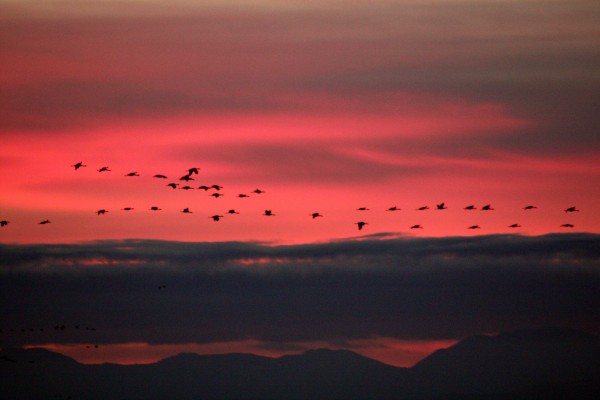
Merced Wildlife Refuge - PHOTO BY ADAM BLAUERT
Merced National Wildlife Refuge
Merced Unit: Auto tour, hiking trails, viewing platforms
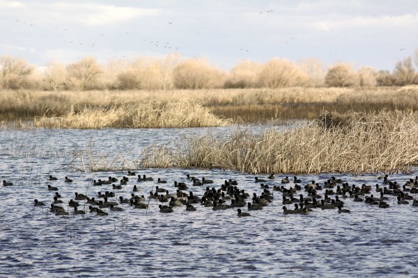
San Luis Refuge - PHOTO BY ADAM BLAUERT
San Luis National Wildlife Refuge
San Luis Unit: Elk and waterfowl auto tours, hiking trails, viewing platforms, visitor center.

San Luis Refuge - PHOTO BY ADAM BLAUERT
San Luis National Wildlife Refuge Complex
The largest unit is the San Luis National Wildlife Refuge Complex, which is made up of several individual units including the Merced National Wildlife Refuge and the San Luis National Wildlife Refuge.
Much of this area is open to the public for a variety of recreational uses.
Tule Elk
In addition to the many avian species, a herd of magnificent tule elk can be viewed in the San Luis Unit on Wolfsen Road north of Los Banos. Once hunted nearly to extinction, stable populations now live in several areas throughout the state.

San Luis Refuge - PHOTO BY ADAM BLAUERT
Birds
The refuge complex is located along the Pacific Flyway, an important migration corridor for dozens of species of waterfowl and other birds.
Some of the most common include Ross’ geese, Aleutian cackling geese, snow geese, green-winged teal, mallard, northern pintail, gadwall, American wigeon, northern shoveler, and white-fronted geese.
The refuge complex constitutes the largest contiguous freshwater wetlands remaining in California.
While wildlife can be viewed throughout the entire year, the wintering populations of lesser Sandhill cranes and Ross’ geese are a highlight. They arrive in the fall and stay until about mid-April, eventually returning to their summer homes in Alaska and Canada.

San Luis Refuge - PHOTO BY ADAM BLAUERT
Some remain throughout the summer and use the area as a breeding ground. During the foggy winter months, afternoon is usually the best time to visit.
In addition to wetlands, vernal pool and upland habitat also abound in the refuge. As the ground dries out in the spring, a brilliant wildflower show occurs in the vernal pool regions.
Visitor Center

Interpretive displays and group programs will be offered. Special tours and programs can be arranged for schools, clubs, and other organizations. For information about the new visitor center click here.
Useful websites for the San Luis Wildlife Refuge Complex
San Luis NWR main website: http://www.fws.gov/sanluis/default.htm
Each refuge area with public access is described below with its principal recreational features and facilities. Check each individual area for specific rules regarding hunting and fishing.
Catfish and bass are the most common fish species. Hunting regulations and types of game vary by area, but can include all waterfowl and upland game birds, deer, and wild pigs. Horses are not permitted.
For additional information, use the web links to access resources provided by the U.S. Fish and Wildlife Service and the California Department of Fish and Game.
Merced National Wildlife Refuge - Merced Unit
The main unit of the Merced NWR is open to both auto touring and hiking on three designated trails. Only a few miles from Merced, this is a great place to spend an afternoon in the fall, winter, or spring.
Location: Sandy Mush Road, west of Highway 59.
Activities and Facilities:
Wildlife viewing
Auto tour route – 5.2 mile auto tour route circles the heart of the refuge with four viewpoints, two observation decks and access to three hiking trails. Visitors are asked to remain in their vehicles except at these points.
Hiking trails
Meadowlark Trail – 1.5 mile loop
Kestrel Trail - .5 mile loop
Bittern Marsh Trail - .6 mile loop
Hunting
Restrooms
A photo blind is available for nature photographers by obtaining a special use permit. Vernal pools can be observed north of Sandy Mush Road. Pets are allowed as long as they remain in vehicles. No fishing is allowed in this refuge area.
Merced National Wildlife Refuge – Lone Tree Unit
This area is only open to hunting.
Location: Sandy Mush Road, west of Highway 59. Adjacent to Merced Unit.
Activities and Facilities
Hunting
San Luis National Wildlife Refuge – Blue Goose Unit
This area is only open to hunting.
Location: Highway 140, east of Gustine. Adjacent to Kesterton Unit.
Activities and Facilities:
Hunting
San Luis National Wildlife Refuge – Freitas Unit
This area is only open to hunting.
Location: Highway 140, east of Gustine. Adjacent to Kesterton Unit.
Activities and Facilities:
Hunting
San Luis National Wildlife Refuge - Kesterson Unit
In the late 1980’s, the selenium-contaminated Kesterton Reservoir was drained, decontaminated, and redeveloped as an addition to the San Luis NWR. It now provides over ten miles of unsigned hiking trails and great opportunities to view wildlife.
Trails are not marked, but visitors are welcome to wander around outside of hunting season.
Location: Highway 140, east of Gustine
Activities and Facilities:
Wildlife viewing
Hiking trails: Kesterton contains a network of over 10 miles of interconnected nature trails. These trails are open from February 15 – September 15.
Hunting
San Luis National Wildlife Refuge - San Luis Unit
This part of the SLNWR offers the widest range of activities. Two auto tour routes and three hiking trails give visitors a chance to observe tule elk and many bird species. The new visitor center is now open. The new visitor center provides an opportunity to learn more about the refuge and its inhabitants.
Location: Wolfsen Road, north of Los Banos.
Activities and Facilities:
Wildlife viewing
Auto tour route
Elk Tour Route – 5 miles
Wetlands and Waterfowl Tour Route – 12 miles
Visitor center
Dogs allowed
Hiking trails
Sousa Trail – 1.2 miles to an observation platform and telescope
Chester Trail – 1 mile (Open February 15 – September 15) This trail leads to the San Joaquin River and the site of Chester, an early settlement in Merced County.
Winton Marsh Trail - .7 mile to an observation platform and benches
Hunting
Fishing – a special access road on the west side of the elk enclosure provides access to all fishing areas.
Restrooms
Drinking fountains
San Luis National Wildlife Refuge - West Bear Creek Unit
This area offers hiking trails and an auto tour route. It receives less visitation than other parts of the San Luis NWR.

San Luis NWR - PHOTO BY ADAM BLAUERT
Location: Highway 165 (Lander Avenue), north of Los Banos
Activities and Facilities
Wildlife viewing
Auto tour route: 2 ¼ mile route around a large wetlands slightly west of the San Joaquin River with two viewpoints.
Hiking trails:
Woody Pond Trail – approximately 1.5 mile loop trail with viewpoint
Raccoon Marsh Trail – approximately 1 mile loop trail with viewpoint
Hunting
Restrooms
Wildlife Refuges Operated by the California Department of Fish and Game
In addition to the 128000 acres managed by the US Fish & Wildlife Service, another 24,000 acres are managed by the California Department of Fish and Game. These include:
Cottonwood Creek Wildlife Area
Los Banos Wildlife Area
North Grasslands Wildlife Area
O’Neill Forebay Wildlife Area
San Luis Reservoir Wildlife Area
Volta Wildlife Area
West Hilmar Wildlife Area
State Wildlife Refuges Map: http://www.dfg.ca.gov/lands/wa/region4/docs/LosBanosGrasslandsVoltaWA.pdf
"Each refuge area with public access is described below with its principal recreational features and facilities. Check each individual area for specific rules regarding hunting and fishing.
Catfish and bass are the most common fish species. Hunting regulations and types of game vary by area, but can include all waterfowl and upland game birds, deer, and wild pigs.
Horses are not permitted. Hiking biking are allowed from the end of the second week in February through September. Bicycles may be ridden on levee roads.
Dogs are permitted and may be off leash from June 6 through the end of March. Drawdown of the waters within the refuges usually takes place in spring and the refuges remain largely dry until the late fall.
For additional information, use the web links to access resources provided by the U.S. Fish and Wildlife Service and the California Department of Fish and Game.”
Cottonwood Creek Wildlife Area
Location: Western edge of Merced County, northeast of Highway 152
Activities:
Wildlife viewing
Hunting
Website: http://www.dfg.ca.gov/lands/wa/region4/cottonwoodcreek.html
Los Banos Wildlife Area
Location: Northeast of Los Banos on Henry Miller Avenue
Fishing and kayaking are allowed on Buttonwillow and Ruth Lakes. Catfish and crappie are the most commonly caught fish species.
Activities and Facilities:
Wildlife viewing
Hunting
Fishing
Boat launch
Restrooms
Drinking fountains
No designated trails, but foot and bike access is allowed throughout the area.
Website: http://www.dfg.ca.gov/lands/wa/region4/losbanos.html
North Grasslands Wildlife Area
China Island Unit: Brazo Road, northeast of Highway 33, between Gustine and Newman
Gadwall Unit: Santa Fe Grade Road, east of Los Banos
Salt Slough Unit: North of Los Banos on Highway 165 (Lander Avenue)
Activities and Facilities:
Wildlife viewing
Hunting
Fishing
Boat launch
Website: http://www.dfg.ca.gov/lands/wa/region4/northgrasslands.html
O’Neill Forebay Wildlife Area
Location: Highway 33, just north of Highway 152. Adjacent to San Luis State Recreation Area.
Activities and Facilities:
Wildlife viewing
Hunting
Restrooms
Website: http://www.dfg.ca.gov/lands/wa/region4/oneillforebay.html
San Luis Reservoir Wildlife Area
Activities and Facilities: South of Highway 152 at Dinosaur Point Road. Adjacent to San Luis State Recreation Area, Pacheco State Park and Upper Cottonwood Creek Wildlife Area.
Wildlife viewing
Hunting
Restrooms
Website: http://www.dfg.ca.gov/lands/wa/region4/sanluisreservoir.html
Volta Wildlife Area
Location: Ingomar Grade Road, northwest of Los Banos.
Activities and Facilities:
Wildlife viewing
Hunting
Website: http://www.dfg.ca.gov/lands/wa/region4/volta.html
West Hilmar Wildlife Area
Location: Four miles south of Hills Ferry on the east side of the San Joaquin River.. Accessible only by boat.
Activities and Facilities:
Wildlife viewing
Hunting
Website: http://www.dfg.ca.gov/lands/wa/region4/wes
Western Merced County boasts over 152,000 acres of wildlife refuges and conservation easements. Making up over 12% of the county’s total land area, these refuges are home to tule elk and a wide range of migratory birds.
Popular for wildlife viewing and hunting, the refuges also offer auto tour routes, hiking trails, and viewing platforms with telescopes.
Fishing is allowed in many areas. Access to all areas is free.
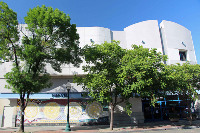
Merced’s Multicultural Arts Center

photo by adam blauert
Downtown Merced’s Multicultural Arts Center
is the local place to enjoy art, purchase art from local artists, and take art and dance classes.
Classes and galleries are operated by the Merced County Arts Council, which has supported art and art education in our area since 1978. Art by local artists is offered for sale in the ground floor area occupied by Arbor Gallery, a local artists’ cooperative.

Second floor gallery - PHOTO BY ADAM BLAUERT
The first and second floors house regularly-rotating exhibits. Special exhibits change several times a year – the last time I visited the main exhibit was an impressive collection of photos by the Merced Camera Club.

Ground floor gallery - PHOTO BY ADAM BLAUERT
Ground floor
Arbor Gallery sells local art in a broad variety of mediums: beautiful paintings, ceramics, photography, drawings, textiles, sculpture, glass, turned wood, jewelry, giclee prints and greeting cards.
Many feature local scenes or are made from local materials. On my recent visit I was surprised by the affordability of many of the pieces I liked the best.
The ground floor also houses a small theater where performances of music and dance are frequently offered.
Arts Merced also partners with the Merced Symphony, Playhouse Merced, the Merced Art Hop, and has sponsored music at downtown locations like Coffee Bandits, the Art Kamangar Center at the Merced Theatre, Merced College, Applegate Park, and the Merced Community Center.
Performances for kids in grades 3-8 are offered on the second Saturday of each month from January through May and September through November.

Stairs to upper levels - PHOTO BY ADAM BLAUERT
The third floor
Offers classes for both children and adults. Frequently offered physical activity courses include world dance and capoeira (a Brazilian martial art that combines dance, acrobatics, and music).
Dance groups Sol del Valle (ballet folk lorico), and Merced Academy of Dance (ballet) also use the building and offer opportunities for local youth to learn traditional dances.
Art classes
Include ceramics, acrylic painting, comic books, drawing basics, painting, digital photography, yarn arts, and. New classes begin monthly.
The center also offers an arts-based adult day program for developmentally disabled adults.
The ARTREE program that puts working artists in local K-12 classrooms is also part of the Merced County Arts Council, along with the Arts in the Valley radio program that airs every Saturday at 8PM on KYOS 1480.
The Arts Center is open 11AM-7PM Wednesday-Thursday and 10AM-5PM Friday-Saturday. Arbor Galley is open 11AM-6PM Tuesday-Friday and 10AM-2PM on Saturdays.
Admission to both the Arts Center and Arbor Gallery is free.
For more information, and for a schedule of events, classes, performances, tours, and special events-see website - click here- MCAC.
or call (209) 388-1090.
For more information about Arbor Gallery, go to Arbor Gallery
or call (209) 384-8338.

Great Bike Paths in Merced County


Bike Paths - photo by adam blauert
Bike Path in Merced
Merced County communities have an extended network of bike paths and bike lanes with many more planned for future construction. This network is made up of three distinct classes of pathways, lanes, and routes.

Bear Creek Bikeway - PHOTO BY ADAM BLAUERT
Class 1: Separate pathway for bikes, pedestrians, skateboards, and other non-motorized uses.
Class 2: A separate bike lane along the edge of a road; indicated by a striped line.
Class 3: A designated route without painted lines to indicate a separate bike lane.

Bike Paths - PHOTO BY ADAM BLAUERT
There are many miles of bike paths in Merced
Merced bike paths on Google Maps (click here)
Great links for local information about bicycling in Merced County.

Bear Creek Bikeway - PHOTO BY ADAM BLAUERT
Additional Information
For additional information on biking, bike maintenance, bike events, and riding in Merced County, check out the website:
Merced Bicycle Coaliton : http://www.mercedbicyclecoalition.org/
Trans_Logo_Large_600

boy on merced city bike trails
Bike Licensing
Bikes owned by residents of the incorporated areas of Merced County (Atwater, Dos Palos, Gustine, Livingston, Los Banos, Merced) must be licensed.
A 3-year license costs $5 and is available from the police station in your city. The information typically required in the license form includes band, model, serial number, wheel size, and frame size.
The City of Merced provides its license information here. CLICK HERE
To obtain a license, visit your local police station
City of Atwater Police Department - 750 Bellevue, Atwater / (209) 357-6385
City of Dos Palos Police Department - 1546 Golden Gate Ave, Dos Palos / (209) 392-2177
City of Gustine Police Department - 682 3rd Ave, Gustine / (209) 854-3737
City of Livingston Police Department - 1446 C Street, Livingston / (209) 394-7916
City of Los Banos Police Department - 945 5th Street, Los Banos / (209) 827-7070
City of Merced Police Department - 611 West 22nd Street, Merced / (209) 385-6912
Bikes on the Bus: Bike racks are provided on Merced County Transit Busses (The Bus).
Adam Blauert, a high school teacher and avid outdoors enthusiast, has dedicated the majority of his life to Merced County. His passions include fishing, backpacking, delving into local history, and exploring the wonders of the western states.