
Merced County Wildlife Refuges

photo by adam blauert
Merced County Wildlife Refuges
Most of the acreage is managed by the U.S. Fish and Wildlife Service, with additional areas under the jurisdiction of the California Department of Fish and Game.
Recommended areas to visit
Merced Wildlife Refuge - PHOTO BY ADAM BLAUERT
Merced National Wildlife Refuge
Merced Unit: Auto tour, hiking trails, viewing platforms
San Luis Refuge - PHOTO BY ADAM BLAUERT
San Luis National Wildlife Refuge
San Luis Unit: Elk and waterfowl auto tours, hiking trails, viewing platforms, visitor center.

San Luis Refuge - PHOTO BY ADAM BLAUERT
San Luis National Wildlife Refuge Complex
The largest unit is the San Luis National Wildlife Refuge Complex, which is made up of several individual units including the Merced National Wildlife Refuge and the San Luis National Wildlife Refuge.
Much of this area is open to the public for a variety of recreational uses.
Tule Elk
In addition to the many avian species, a herd of magnificent tule elk can be viewed in the San Luis Unit on Wolfsen Road north of Los Banos. Once hunted nearly to extinction, stable populations now live in several areas throughout the state.

San Luis Refuge - PHOTO BY ADAM BLAUERT
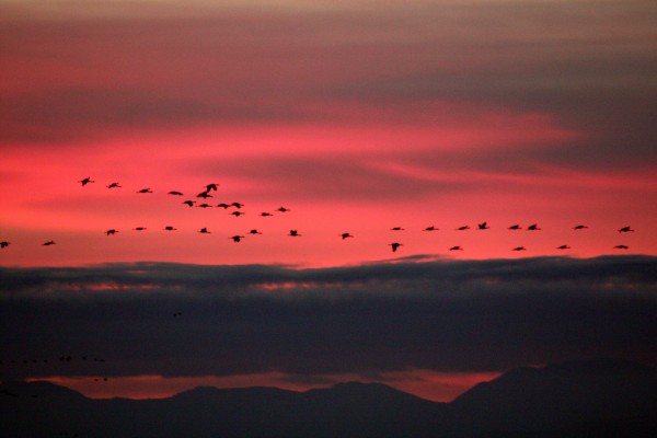
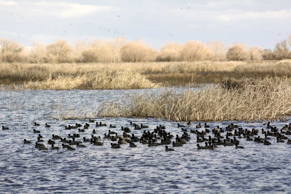
Birds
The refuge complex is located along the Pacific Flyway, an important migration corridor for dozens of species of waterfowl and other birds.
Some of the most common include Ross’ geese, Aleutian cackling geese, snow geese, green-winged teal, mallard, northern pintail, gadwall, American wigeon, northern shoveler, and white-fronted geese.
The refuge complex constitutes the largest contiguous freshwater wetlands remaining in California.
While wildlife can be viewed throughout the entire year, the wintering populations of lesser Sandhill cranes and Ross’ geese are a highlight. They arrive in the fall and stay until about mid-April, eventually returning to their summer homes in Alaska and Canada.

San Luis Refuge - PHOTO BY ADAM BLAUERT
Some remain throughout the summer and use the area as a breeding ground. During the foggy winter months, afternoon is usually the best time to visit.
In addition to wetlands, vernal pool and upland habitat also abound in the refuge. As the ground dries out in the spring, a brilliant wildflower show occurs in the vernal pool regions.
Visitor Center

Interpretive displays and group programs will be offered. Special tours and programs can be arranged for schools, clubs, and other organizations. For information about the new visitor center click here.
Useful websites for the San Luis Wildlife Refuge Complex
San Luis NWR main website: http://www.fws.gov/sanluis/default.htm
Each refuge area with public access is described below with its principal recreational features and facilities. Check each individual area for specific rules regarding hunting and fishing.
Catfish and bass are the most common fish species. Hunting regulations and types of game vary by area, but can include all waterfowl and upland game birds, deer, and wild pigs. Horses are not permitted.
For additional information, use the web links to access resources provided by the U.S. Fish and Wildlife Service and the California Department of Fish and Game.
Merced National Wildlife Refuge - Merced Unit
The main unit of the Merced NWR is open to both auto touring and hiking on three designated trails. Only a few miles from Merced, this is a great place to spend an afternoon in the fall, winter, or spring.
Location: Sandy Mush Road, west of Highway 59.
Activities and Facilities:
Wildlife viewing
Auto tour route – 5.2 mile auto tour route circles the heart of the refuge with four viewpoints, two observation decks and access to three hiking trails. Visitors are asked to remain in their vehicles except at these points.
Hiking trails
Meadowlark Trail – 1.5 mile loop
Kestrel Trail - .5 mile loop
Bittern Marsh Trail - .6 mile loop
Hunting
Restrooms
A photo blind is available for nature photographers by obtaining a special use permit. Vernal pools can be observed north of Sandy Mush Road. Pets are allowed as long as they remain in vehicles. No fishing is allowed in this refuge area.
Merced National Wildlife Refuge – Lone Tree Unit
This area is only open to hunting.
Location: Sandy Mush Road, west of Highway 59. Adjacent to Merced Unit.
Activities and Facilities
Hunting
San Luis National Wildlife Refuge – Blue Goose Unit
This area is only open to hunting.
Location: Highway 140, east of Gustine. Adjacent to Kesterton Unit.
Activities and Facilities:
Hunting
San Luis National Wildlife Refuge – Freitas Unit
This area is only open to hunting.
Location: Highway 140, east of Gustine. Adjacent to Kesterton Unit.
Activities and Facilities:
Hunting
San Luis National Wildlife Refuge - Kesterson Unit
In the late 1980’s, the selenium-contaminated Kesterton Reservoir was drained, decontaminated, and redeveloped as an addition to the San Luis NWR. It now provides over ten miles of unsigned hiking trails and great opportunities to view wildlife.
Trails are not marked, but visitors are welcome to wander around outside of hunting season.
Location: Highway 140, east of Gustine
Activities and Facilities:
Wildlife viewing
Hiking trails: Kesterton contains a network of over 10 miles of interconnected nature trails. These trails are open from February 15 – September 15.
Hunting
San Luis National Wildlife Refuge - San Luis Unit
This part of the SLNWR offers the widest range of activities. Two auto tour routes and three hiking trails give visitors a chance to observe tule elk and many bird species. The new visitor center is now open. The new visitor center provides an opportunity to learn more about the refuge and its inhabitants.
Location: Wolfsen Road, north of Los Banos.
Activities and Facilities:
Wildlife viewing
Auto tour route
Elk Tour Route – 5 miles
Wetlands and Waterfowl Tour Route – 12 miles
Visitor center
Dogs allowed
Hiking trails
Sousa Trail – 1.2 miles to an observation platform and telescope
Chester Trail – 1 mile (Open February 15 – September 15) This trail leads to the San Joaquin River and the site of Chester, an early settlement in Merced County.
Winton Marsh Trail - .7 mile to an observation platform and benches
Hunting
Fishing – a special access road on the west side of the elk enclosure provides access to all fishing areas.
Restrooms
Drinking fountains
San Luis National Wildlife Refuge - West Bear Creek Unit
This area offers hiking trails and an auto tour route. It receives less visitation than other parts of the San Luis NWR.

San Luis NWR - PHOTO BY ADAM BLAUERT
Location: Highway 165 (Lander Avenue), north of Los Banos
Activities and Facilities
Wildlife viewing
Auto tour route: 2 ¼ mile route around a large wetlands slightly west of the San Joaquin River with two viewpoints.
Hiking trails:
Woody Pond Trail – approximately 1.5 mile loop trail with viewpoint
Raccoon Marsh Trail – approximately 1 mile loop trail with viewpoint
Hunting
Restrooms
Wildlife Refuges Operated by the California Department of Fish and Game
In addition to the 128000 acres managed by the US Fish & Wildlife Service, another 24,000 acres are managed by the California Department of Fish and Game. These include:
Cottonwood Creek Wildlife Area
Los Banos Wildlife Area
North Grasslands Wildlife Area
O’Neill Forebay Wildlife Area
San Luis Reservoir Wildlife Area
Volta Wildlife Area
West Hilmar Wildlife Area
State Wildlife Refuges Map: http://www.dfg.ca.gov/lands/wa/region4/docs/LosBanosGrasslandsVoltaWA.pdf
"Each refuge area with public access is described below with its principal recreational features and facilities. Check each individual area for specific rules regarding hunting and fishing.
Catfish and bass are the most common fish species. Hunting regulations and types of game vary by area, but can include all waterfowl and upland game birds, deer, and wild pigs.
Horses are not permitted. Hiking biking are allowed from the end of the second week in February through September. Bicycles may be ridden on levee roads.
Dogs are permitted and may be off leash from June 6 through the end of March. Drawdown of the waters within the refuges usually takes place in spring and the refuges remain largely dry until the late fall.
For additional information, use the web links to access resources provided by the U.S. Fish and Wildlife Service and the California Department of Fish and Game.”
Cottonwood Creek Wildlife Area
Location: Western edge of Merced County, northeast of Highway 152
Activities:
Wildlife viewing
Hunting
Website: http://www.dfg.ca.gov/lands/wa/region4/cottonwoodcreek.html
Los Banos Wildlife Area
Location: Northeast of Los Banos on Henry Miller Avenue
Fishing and kayaking are allowed on Buttonwillow and Ruth Lakes. Catfish and crappie are the most commonly caught fish species.
Activities and Facilities:
Wildlife viewing
Hunting
Fishing
Boat launch
Restrooms
Drinking fountains
No designated trails, but foot and bike access is allowed throughout the area.
Website: http://www.dfg.ca.gov/lands/wa/region4/losbanos.html
North Grasslands Wildlife Area
China Island Unit: Brazo Road, northeast of Highway 33, between Gustine and Newman
Gadwall Unit: Santa Fe Grade Road, east of Los Banos
Salt Slough Unit: North of Los Banos on Highway 165 (Lander Avenue)
Activities and Facilities:
Wildlife viewing
Hunting
Fishing
Boat launch
Website: http://www.dfg.ca.gov/lands/wa/region4/northgrasslands.html
O’Neill Forebay Wildlife Area
Location: Highway 33, just north of Highway 152. Adjacent to San Luis State Recreation Area.
Activities and Facilities:
Wildlife viewing
Hunting
Restrooms
Website: http://www.dfg.ca.gov/lands/wa/region4/oneillforebay.html
San Luis Reservoir Wildlife Area
Activities and Facilities: South of Highway 152 at Dinosaur Point Road. Adjacent to San Luis State Recreation Area, Pacheco State Park and Upper Cottonwood Creek Wildlife Area.
Wildlife viewing
Hunting
Restrooms
Website: http://www.dfg.ca.gov/lands/wa/region4/sanluisreservoir.html
Volta Wildlife Area
Location: Ingomar Grade Road, northwest of Los Banos.
Activities and Facilities:
Wildlife viewing
Hunting
Website: http://www.dfg.ca.gov/lands/wa/region4/volta.html
West Hilmar Wildlife Area
Location: Four miles south of Hills Ferry on the east side of the San Joaquin River.. Accessible only by boat.
Activities and Facilities:
Wildlife viewing
Hunting
Website: http://www.dfg.ca.gov/lands/wa/region4/wes
Western Merced County boasts over 152,000 acres of wildlife refuges and conservation easements. Making up over 12% of the county’s total land area, these refuges are home to tule elk and a wide range of migratory birds.
Popular for wildlife viewing and hunting, the refuges also offer auto tour routes, hiking trails, and viewing platforms with telescopes.
Fishing is allowed in many areas. Access to all areas is free.
Adam Blauert, a high school teacher and avid outdoors enthusiast, has dedicated the majority of his life to Merced County. His passions include fishing, backpacking, delving into local history, and exploring the wonders of the western states.