Chowchilla’s Historical Society & Museum
Every community should have a museum to display photos, documents, and artifacts that bring its past to life.
PHOTO BY ADAM BLAUERT
Just over a year ago, Chowchilla’s Historical Society made the dream of a museum a reality. With the support of the Chowchilla Fair’s Board of Directors, a former storage building at the Chowchilla-Madera Fairgrounds was transformed into an interesting history display.
If you live in Chowchilla or the surrounding area, have a family connection to Chowchilla, or are interested in local history in general, you will probably find the museum’s exhibits interesting.
Growing up with a great aunt and uncle who lived in Chowchilla, and many relatives (including my great-grandparents) buried in the cemetery, we usually visited at least a couple of times a year.
Despite this, I knew relatively little about the town’s history until my recent visit to the museum.
PHOTO BY ADAM BLAUERT
Most of the earliest towns in our valley were planned out by the Southern Pacific Railroad in the 1870s as it built southwards from the transcontinental railroad line at Lathrop.
Some of these include Merced, Modesto, Fresno, Tulare and Bakersfield.
A large number of later towns and surrounding farms were created and sold by land companies, many of which guaranteed irrigation water from local rivers for the purchasers of the land.
Chowchilla and the nearby community of Dairyland were organized on this model, a system sometimes referred to as “colonies” elsewhere in the valley.
PHOTO BY ADAM BLAUERT
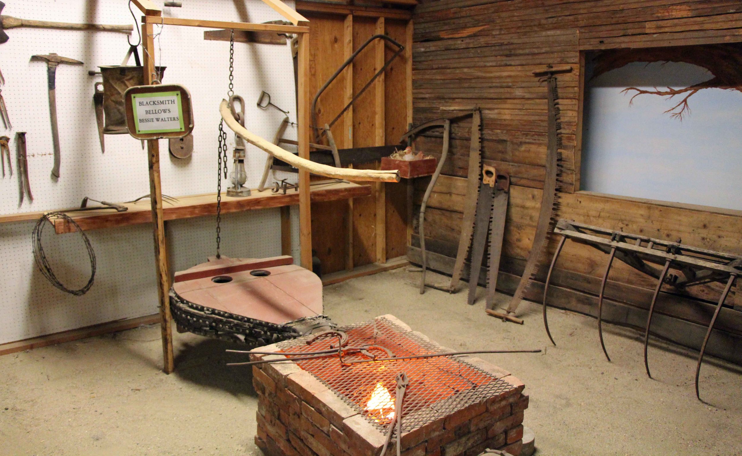
The Chowchilla Historical Society has been collecting artifacts, documents, and stories since 1983. Some of the displays currently in the museum include:
A slideshow of historic photos of the town
The Chowchilla Pacific Railway – a local route that connected to the Southern Pacific and ran 7miles southwest to Dairyland and about 5 miles beyond with an original plan to connect all the way to the coast
Chowchilla schools
A 1940s kitchen created with artifacts from local kitchens
A recreation of a typical blacksmith shop
1950s vintage dairy equipment, reflecting the role of the dairy industry in Chowchilla’s history and the dramatic changes in technology that have taken place in the last 60 years
A road grader that was used to build Robertson Boulevard
A 1/7 scale reproduction of the famous Chowchilla arch that greeted visitors until it was destroyed by fire in 1937, but which has since been represented on the town’s welcome signs and the city’s official seal
A restored Kleiber logging truck that was used in Sierra Nevada logging and then retrofitted as a water tanker for watering an orchard near Chowchilla
PHOTO BY ADAM BLAUERT
Photo by Adam Blauert
I visited the museum for the first time in January during the second annual open house.
PHOTO BY ADAM BLAUERT
Due to staffing limitations, the museum only has regular hours during the fair and (May 19-22, 2016) but appointments can be scheduled to tour the museum by contacting Chris Thomas, the museum curator, at (559) 665-1920.
For more information about the fair, go to http://chowchillafair.org/.
Chris and the other members of the historical society are friendly and extremely knowledgeable about the area’s history. I enjoyed my visit and learned a lot about the history of the Chowchilla – Dairyland area.
School groups and other groups are always welcome for tours. The Chowchilla Historical Society continues to work on adding and improving exhibits and welcomes the participation of more members of the community. For membership information, contact Chris Thomas at the phone number listed above.
The City of Chowchilla’s website has some interesting historic photos of the town that can be accessed at:
The museum is located close to several other local museums including:
To find the museum, exit Highway 99 at Robertson Boulevard and drive west.
Turn left on 5th Street. After the road bends right, look for the fairgrounds on the left. Turn left by the lighted sign and drive into the fairgrounds.
The museum will be on your left after you pass a large covered arena.
PHOTO BY ADAM BLAUERT
PHOTO BY ADAM BLAUERT

Hensley lake ~ Very close to Merced County with many facilities

PHOTO BY ADAM BLAUERT
Hensley Lake
Less visited than nearby Eastman Lake, Hensley Lake has almost as many facilities and comparable fishing. Hensley Lake was created by a dam on the Fresno River.

Hensley Lake - PHOTO BY ADAM BLAUERT
Location: Roads 603 and 400 in Madera County
Distance from Merced: 42 miles
Distance from Los Banos: 69 miles
Operating Authority: U.S. Army Corps of Engineers
Surface Area of Lake: 1,570 acres

Hensley - PHOTO BY ADAM BLAUERT
Facilities and Activities:
Boat ramp
Chemical/flush restrooms
Drinking fountains
Campgrounds/group campgrounds with BBQ grills/fire rings, shelters, hot showers, electric hookups
Picnic areas with tables, shelters, and BBQ grills
Group picnic areas and shelters
Swimming area
Playground
Dump station
Hiking/biking/equestrian trails
Wildlife viewing area
Horseshoe pits
Dogs allowed? Yes
Horses allowed? Yes, and a large network of equestrian trails are available
Hunting allowed? Yes
Fish species: Bass, bluegill, catfish, crappie, sunfish. Rainbow trout during winter months.
Boat rentals: No

Hensley - PHOTO BY ADAM BLAUERT


Eastman Lake: Formed by a dam on the Chowchilla reservoir, this tends to be more popular than nearby Hensley Lake.

Eastman Lake
Eastman Lake: Formed by a dam on the Chowchilla reservoir, this tends to be more popular than nearby Hensley Lake.
Location: Road 29, Madera County
Distance from Merced: 43 miles
Distance from Los Banos: 70 miles
Operating authority: U.S. Army Corps of Engineers
Surface area of lake: 1,780 acres
Facilities and activities
Boat ramps
Flush restrooms
Drinking fountains
Visitor center
Campgrounds/group campgrounds with BBQ grills/fire rings, shelters, hot showers, RV hookups
Picnic areas with tables, shelters, and BBQ grills
Group picnic areas and shelters
Swimming beach
Playground
Dump station
Hiking/biking/equestrian trails
Wildlife viewing area
Softball diamond
Volleyball courts
Horseshoe pits
Hunting permitted
Dogs allowed? Yes
Horses and hunting
Yes - a large network of equestrian trails and an equestrian campground are available.
Hunting allowed? Yes
Fish species
Bass, bluegill, catfish, crappie. Rainbow trout during winter months.
Boat rentals: No
Adam Blauert, a high school teacher and avid outdoors enthusiast, has dedicated the majority of his life to Merced County. His passions include fishing, backpacking, delving into local history, and exploring the wonders of the western states.